Data
- Obtaining
- Supplying
- High-Frequency
- Bottom Pressure Records
- Other Long Records
- GLOSS/ODINAFRICA Calibration Data
Donate
Donate to PSMSL
Data Notes
- Individual Station Data and Plot Notes
- Referencing the Data Set
- PSMSL Help File
- 2010 Changes to the PSMSL Data Files
Extracted from Database
03 Mar 2025
Station Information
| Station ID: | 256 |
| Latitude: | 32.866667 |
| Longitude: | -117.256667 |
| GLOSS ID: | 159 |
| Coastline code: | 823 |
| Station code: | 71 |
| Country: | UNITED STATES |
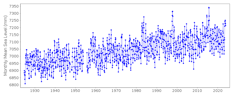
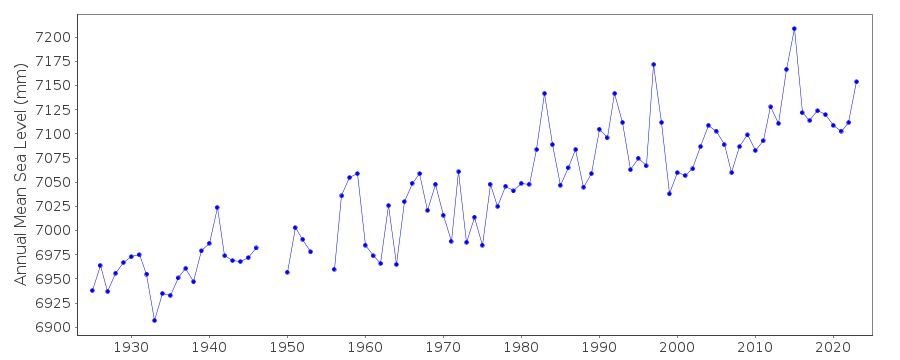
| Time span of data: | 1924 – 2024 |
| Completeness (%): | 96 |
| Date of last update: | 07 Jan 2025 |
| Green Arrow: | Current Station |
| Yellow Marker: | Neighbouring RLR Station |
| Red Marker: | Neighbouring Metric Station |
Please note: In many cases, the station position in our database is accurate to only one minute. Thus, the tide gauge may not appear to be on the coast.
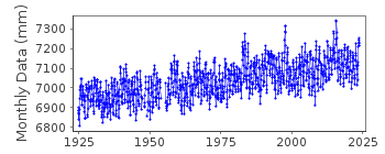
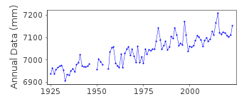
Tide Gauge Data
Additional Data Sources (guide to additional data sources)
Nearby GNSS Stations from SONEL: SPW2, SIO5, SIO3Nearby Real Time Stations from VLIZ: lajo2, lajo
Fast Delivery Data from UHSLC station 554: hourly and daily
Research Quality Data from UHSLC station 554: hourly and daily
Station Documentation
Link to RLR information.Documentation added 1991-06-11
La Jolla (Scripps) 823/071 RLR(1964) is 14.1m below BM1Documentation added 2011-08-25
Using NOAA data the RLR diagram has been re-drawn. Primary benchmark is now 7 1958 12.299m above gauge datum. The previously used benchmark BM1 9.178m above gauge datum no longer appears in the NOAA reportsDocumentation added 2018-02-20
When 2017 data was downloaded it was obvious that areas of the complete dataset had been revised. Revised values have been included or removed for 1947-1949, 1955, 1973, 1977-1980,1989-1990, 1993-1995,1999,2006-2007 and 2010-2012. Because of these revisions the complete dataset was reloaded onto the database.Data Authority
N.O.A.A. / N.O.S.N/oes33, Ssmc4, Room 6531
1305 East-West Highway
Silver Spring,
MD 20910

![]()
![]()
![]()
