Data
- Obtaining
- Supplying
- High-Frequency
- Bottom Pressure Records
- Other Long Records
- GLOSS/ODINAFRICA Calibration Data
Donate
Donate to PSMSL
Data Notes
- Individual Station Data and Plot Notes
- Referencing the Data Set
- PSMSL Help File
- 2010 Changes to the PSMSL Data Files
Extracted from Database
03 Mar 2025
Station Information
| Station ID: | 258 |
| Latitude: | 37.735583 |
| Longitude: | -25.671408 |
| GLOSS ID: | 245 |
| Coastline code: | 360 |
| Station code: | 1 |
| Country: | PORTUGAL |
| Time span of RLR data: | 1978 – 2018 |
| RLR completeness (%): | 74 |
| Time span of metric data: | 1924 – 2018 |
| Metric completeness (%): | 63 |
| MTL Data: | 1924-1963 |
| MTL-MSL (mm): | 3 |
| Link to ellipsoid: | Available |
| Date of last update: | 13 Aug 2019 |
| Green Arrow: | Current Station |
| Yellow Marker: | Neighbouring RLR Station |
| Red Marker: | Neighbouring Metric Station |
Please note: In many cases, the station position in our database is accurate to only one minute. Thus, the tide gauge may not appear to be on the coast.
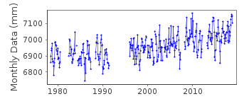
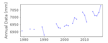
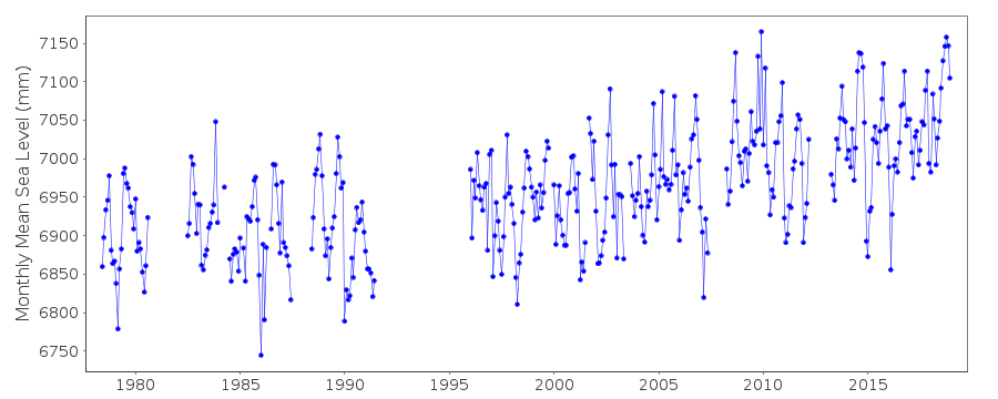
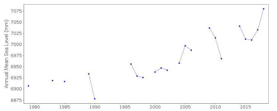
Tide Gauge Data
Additional Data Sources (guide to additional data sources)
Nearby GNSS Stations from SONEL: PDELNearby Real Time Stations from VLIZ: pdas
Fast Delivery Data from UHSLC station 211: hourly and daily
Research Quality Data from UHSLC station 211: hourly and daily
Station Documentation
Link to RLR information.Documentation - date unknown
PRIOR TO 1978 DATA SUPPLIED BY AUTHORITY CODE NO. 95Documentation added 1998-11-04
data for 1990-91 replaced with revised values received from authority 41Documentation added 2006-10-30
Following the supply of data 1978-2005 banked data revised and updated RLR value also calculated. FCODE in STTN table revised from HL to 24. However data 1924-1977 are Mean Tide Level(MTL) values.Documentation added 2011-10-03
It has come to our notice that there was an error in the RLR diagram for Ponta Delgada. The diagram has been re-calculated, as a result the RLR factor changed from 5.887m to 5.871m. The data has been adjusted.Documentation added 2016-01-22
A value of MTL-MSL=3 mm has been derived using the GESLA2 (high-frequency tide gauge) dataset using harmonic constituents. As the correction is only applied to RLR data and the data from 1924-1977 is metric, it is not used in the data set. Should this period become RLR in future it would be used.Data Authority
Hydrographic InstituteRua das Trinas 49
1249-093 Lisboa

![]()
![]()
![]()
