Data
- Obtaining
- Supplying
- High-Frequency
- Bottom Pressure Records
- Other Long Records
- GLOSS/ODINAFRICA Calibration Data
Donate
Donate to PSMSL
Data Notes
- Individual Station Data and Plot Notes
- Referencing the Data Set
- PSMSL Help File
- 2010 Changes to the PSMSL Data Files
Extracted from Database
01 Jun 2026
Station Information
| Station ID: | 260 |
| Latitude: | 6.066667 |
| Longitude: | 121 |
| GLOSS ID: | 70 |
| Coastline code: | 660 |
| Station code: | 141 |
| Country: | PHILIPPINES |
| Time span of RLR data: | 1947 – 1996 |
| RLR completeness (%): | 85 |
| Time span of metric data: | 1924 – 1996 |
| Metric completeness (%): | 62 |
| Date of last update: | 30 Mar 1999 |
| Green Arrow: | Current Station |
| Yellow Marker: | Neighbouring RLR Station |
| Red Marker: | Neighbouring Metric Station |
Please note: In many cases, the station position in our database is accurate to only one minute. Thus, the tide gauge may not appear to be on the coast.
Tide Gauge Data
Additional Data Sources (guide to additional data sources)
Research Quality Data from UHSLC station 373: hourly and dailyStation Documentation
Link to RLR information.Documentation added 1991-06-11
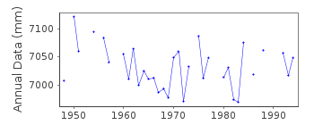
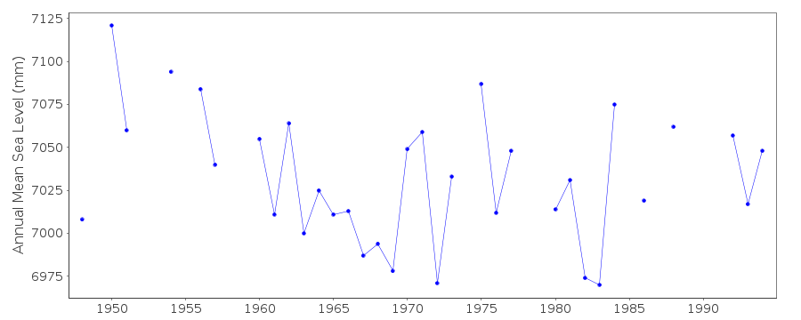
Jolo 660/141 RLR(1963) is 9.3m below BM1Documentation added 1993-06-17
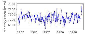
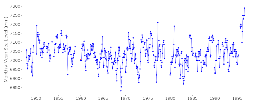
December 1959 for Jolo is anomalously large.Documentation added 1999-03-30
gauge type = Leupold & Stevens/EMS-16Documentation added 1999-07-29
For 1996 there is no change in the datum of observations reported. There are lengthy gaps which may be relevant to the apparent higher values.Data Authority
National Mapping and Resource Information AuthorityHydrography Department
421 Barraca St,
San Nicolas 1010
Manila

![]()
![]()
![]()
