Data
- Obtaining
- Supplying
- High-Frequency
- Bottom Pressure Records
- Other Long Records
- GLOSS/ODINAFRICA Calibration Data
Donate
Donate to PSMSL
Data Notes
- Individual Station Data and Plot Notes
- Referencing the Data Set
- PSMSL Help File
- 2010 Changes to the PSMSL Data Files
Extracted from Database
03 Mar 2025
Station Information
| Station ID: | 3 |
| Latitude: | 51.445639 |
| Longitude: | 0.743444 |
| Coastline code: | 170 |
| Station code: | 101 |
| Country: | UNITED KINGDOM |
| Time span of RLR data: | 1832 – 2024 |
| RLR completeness (%): | 52 |
| Time span of metric data: | 1832 – 2024 |
| Metric completeness (%): | 55 |
| Link to ellipsoid: | Available |
| Date of last update: | 19 Feb 2025 |
| Green Arrow: | Current Station |
| Yellow Marker: | Neighbouring RLR Station |
| Red Marker: | Neighbouring Metric Station |
Please note: In many cases, the station position in our database is accurate to only one minute. Thus, the tide gauge may not appear to be on the coast.
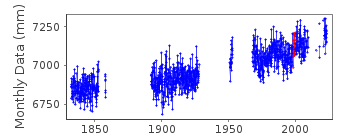
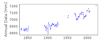
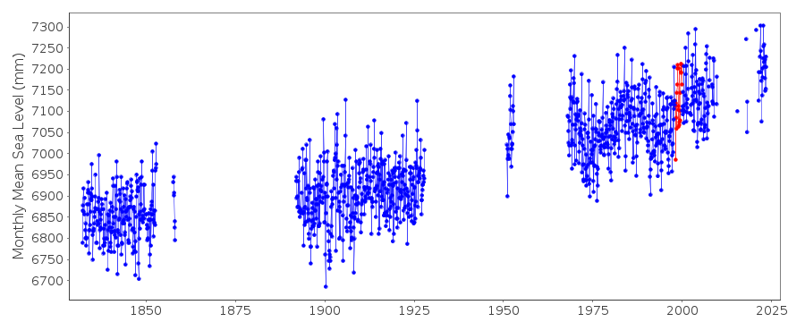
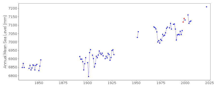
Tide Gauge Data
Additional Data Sources (guide to additional data sources)
Nearby GNSS Stations from SONEL: SHRN, SHEENearby Real Time Stations from VLIZ: shee2, shee
Station Documentation
Link to RLR information.Documentation added 1991-06-11
Sheerness 170/101 RLR(1975) is 11.6m below BM TQ9080 7549Documentation added 1994-07-20
Sheerness was the site of the first self-recording tide gauge (see Tides, Surges and Mean Sea-Level by D.T.Pugh, 1987. Wiley).Documentation added 1994-09-20
Details are obscure until a Lege gauge was installed in August 1955 - 1832-1955 records are held by POL but gauge make is not known. The Lege was replaced by a Munro in November 1962, moved to a new site in April 1963 and again in May 1973, replaced by an Ott in 1980, an Aanderaa pressure system in July 1983, and an "A Class" bubbler gauge from October 1986.Documentation added 2000-04-26
Values for 1998- appear slightly higher than anticipated from inspection of neighbouring records - cause may be instrumental.Documentation added 2001-01-02
Recent work on vertical land movements in the UK can be found from the University of Nottingham web site: http://ukcogr.iessg.nottingham.ac.uk/~eosi/Documentation added 2013-05-09
Last data for Sheerness is 2009. This is because the primary channel is recording 1-2m high possibly due to bio-foulingDocumentation added 2014-07-04
There were no MSL's produced for 2013 for Sheerness. The primary channel is still recording a constant value of around -1.026m. A site visit was made on 08.01.2013 to perform levelling at the site and investigate the blocking of the primary channel. However, the channel could not be cleared and will require divers to clear the blockage. A visit was also carried out on 05.06.2013 for general maintenance.Data Authority
Environment AgencyHorizon House
Deanery Road
BS1 5AH
Bristol

![]()
![]()
![]()
