Data
- Obtaining
- Supplying
- High-Frequency
- Bottom Pressure Records
- Other Long Records
- GLOSS/ODINAFRICA Calibration Data
Donate
Donate to PSMSL
Data Notes
- Individual Station Data and Plot Notes
- Referencing the Data Set
- PSMSL Help File
- 2010 Changes to the PSMSL Data Files
Extracted from Database
03 Mar 2025
Station Information
| Station ID: | 311 |
| Latitude: | 38.983333 |
| Longitude: | -76.48 |
| Coastline code: | 960 |
| Station code: | 80 |
| Country: | UNITED STATES |
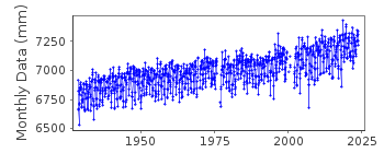
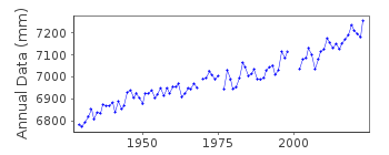
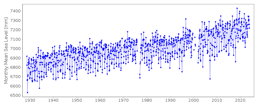
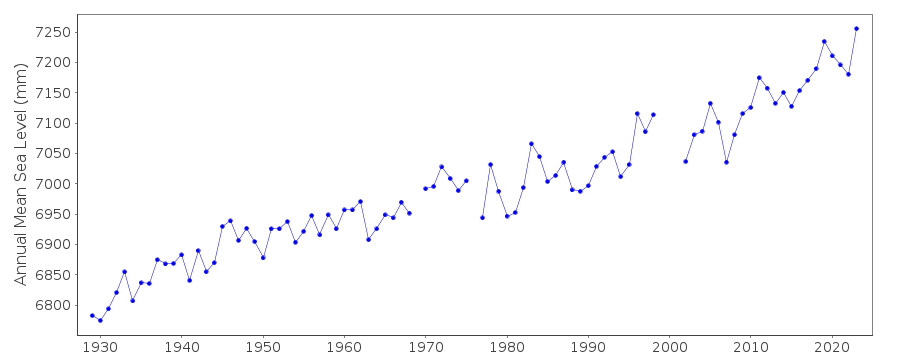
| Time span of data: | 1928 – 2024 |
| Completeness (%): | 96 |
| Date of last update: | 07 Jan 2025 |
| Green Arrow: | Current Station |
| Yellow Marker: | Neighbouring RLR Station |
| Red Marker: | Neighbouring Metric Station |
Please note: In many cases, the station position in our database is accurate to only one minute. Thus, the tide gauge may not appear to be on the coast.
Tide Gauge Data
Additional Data Sources (guide to additional data sources)
Nearby GNSS Stations from SONEL: ANP6, USNA, LOYF, ANP1, ANP5Station Documentation
Link to RLR information.Documentation added 1991-06-11
Annapolis 960/080 RLR(1974) is 8.4m below BM1Documentation added 1993-07-29
Low values in early 1977 follow a data gap but are probably correct - for example, compare to 960/081 Baltimore. Previously this data had been flagged but because Baltimore compares well the flags have been removed.Documentation added 2011-10-12
Using NOAA data the RLR diagram has been revised. Previous Primary benchmark was BM 1 now referred to as BM 1 1928. Original value was 2.957m above the gauge datum. In 1986 this value was 2.949m and in 2003 2.942m New Primary benchmark is BM 7 with a value of 2.876m in 1986 and 2.869m in 2003.Data Authority
N.O.A.A. / N.O.S.N/oes33, Ssmc4, Room 6531
1305 East-West Highway
Silver Spring,
MD 20910

![]()
![]()
![]()
