Data
- Obtaining
- Supplying
- High-Frequency
- Bottom Pressure Records
- Other Long Records
- GLOSS/ODINAFRICA Calibration Data
Donate
Donate to PSMSL
Data Notes
- Individual Station Data and Plot Notes
- Referencing the Data Set
- PSMSL Help File
- 2010 Changes to the PSMSL Data Files
Extracted from Database
22 Jun 2026
WARNING: QCFLAG EXISTS. PLEASE READ THE DOCUMENTATION.
Station Information
| Station ID: | 359 |
| Latitude: | 34.918889 |
| Longitude: | 139.825 |
| GLOSS ID: | 86 |
| Coastline code: | 642 |
| Station code: | 61 |
| Country: | JAPAN |
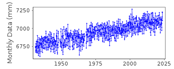
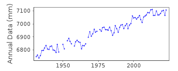
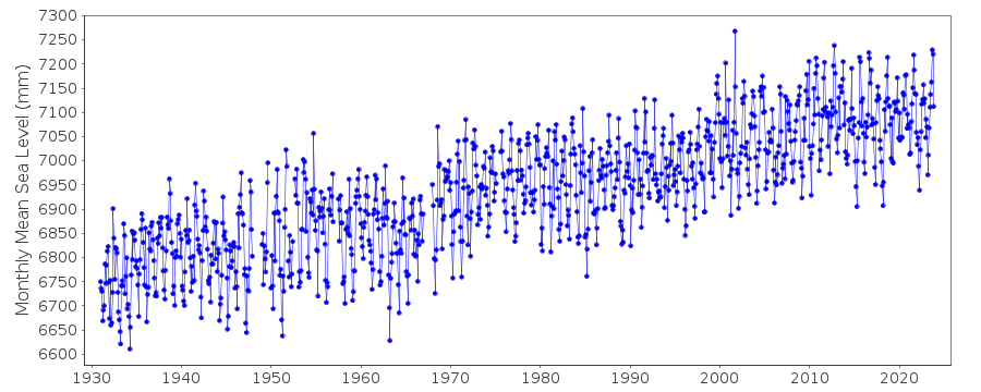
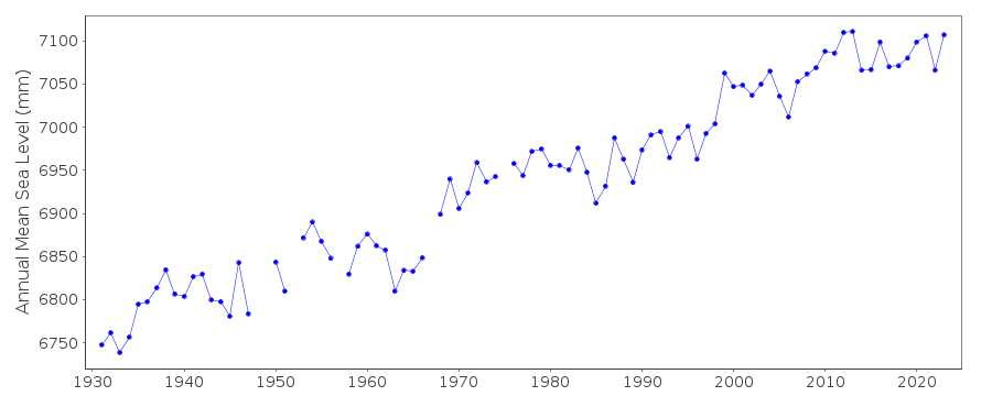
| Time span of data: | 1931 – 2025 |
| Completeness (%): | 96 |
| Link to ellipsoid: | Available |
| Date of last update: | 01 Apr 2026 |
| Green Arrow: | Current Station |
| Yellow Marker: | Neighbouring RLR Station |
| Red Marker: | Neighbouring Metric Station |
Please note: In many cases, the station position in our database is accurate to only one minute. Thus, the tide gauge may not appear to be on the coast.
Tide Gauge Data
Additional Data Sources (guide to additional data sources)
Nearby GNSS Stations from SONEL: P206Nearby Real Time Stations from VLIZ: mera
Fast Delivery Data from UHSLC station 352: hourly and daily
Research Quality Data from UHSLC station 352: hourly and daily
Station Documentation
Link to RLR information.Documentation added 1991-06-11
Mera 642/061 RLR(1976) is 11.2m below Attached BMDocumentation added 1993-07-12
Several apparent datum problems in the 1950s and 1960sDocumentation added 2011-02-22
By buddy checking the data for Mera against that for Aburatsubo and adding the residuals there does seem to be datum problems during the late 40's through to the mid 60's.Documentation added 2012-02-21
A massive earthquake of magnitude 9.0 occurred at 14:46 JST (05:46 UTC) on Friday 11th March 2011 with the epicenter approx. 70km east of the Oshika Peninsula of Tohoku. It was the most powerful known earthquake to hit Japan generating a tsunami with waves up to 40.5m travelling up to 10km inland.Documentation added 2014-03-13
The GPS benchmark information has been downloaded from the SONEL website. GPS benchmark P206 is 16.204m above RLR.Data Authority
Japan Meteorological Agency3-6-9 Toranomon, Minato City
Tokyo

![]()
![]()
![]()
