Data
- Obtaining
- Supplying
- High-Frequency
- Bottom Pressure Records
- Other Long Records
- GLOSS/ODINAFRICA Calibration Data
Donate
Donate to PSMSL
Data Notes
- Individual Station Data and Plot Notes
- Referencing the Data Set
- PSMSL Help File
- 2010 Changes to the PSMSL Data Files
Extracted from Database
03 Mar 2025
Station Information
| Station ID: | 362 |
| Latitude: | 40.793333 |
| Longitude: | -73.781667 |
| Coastline code: | 960 |
| Station code: | 141 |
| Country: | UNITED STATES |
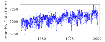
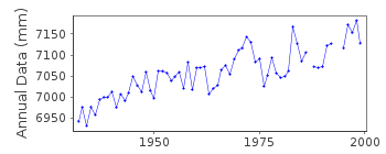
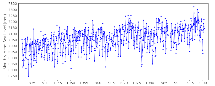
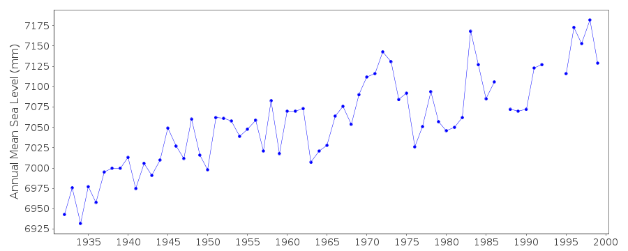
| Time span of data: | 1931 – 2000 |
| Completeness (%): | 97 |
| Date of last update: | 01 Jun 2001 |
| Green Arrow: | Current Station |
| Yellow Marker: | Neighbouring RLR Station |
| Red Marker: | Neighbouring Metric Station |
Please note: In many cases, the station position in our database is accurate to only one minute. Thus, the tide gauge may not appear to be on the coast.
Tide Gauge Data
Station Documentation
Link to RLR information.Documentation added 1991-06-11
Willets Point 960/141 RLR(1964) is 10.2m below BM737Documentation added 1993-07-12
Willets Point 960/141 RLR(1964) is 10.2m below BM737Documentation added 2011-08-11
Using NOAA data the RLR diagram was re-drawn. Primary benchmark NO 3 1944 is5.115m above gauge datum.
Previous PSMSL benchmark BM 737 5.831m above gauge datum no longer appears in
the NOAA reports.
Documentation added 2015-02-23
NOAA website confirms station was removed in November 2000.Data Authority
N.O.A.A. / N.O.S.N/oes33, Ssmc4, Room 6531
1305 East-West Highway
Silver Spring,
MD 20910

![]()
![]()
![]()
