Data
- Obtaining
- Supplying
- High-Frequency
- Bottom Pressure Records
- Other Long Records
- GLOSS/ODINAFRICA Calibration Data
Donate
Donate to PSMSL
Data Notes
- Individual Station Data and Plot Notes
- Referencing the Data Set
- PSMSL Help File
- 2010 Changes to the PSMSL Data Files
Extracted from Database
02 Mar 2026
Station Information
| Station ID: | 368 |
| Latitude: | 32.373333 |
| Longitude: | -64.703333 |
| GLOSS ID: | 221 |
| Coastline code: | 950 |
| Station code: | 11 |
| Country: | BERMUDA |
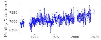
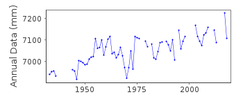
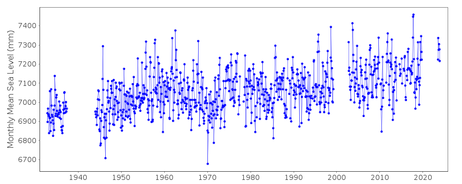
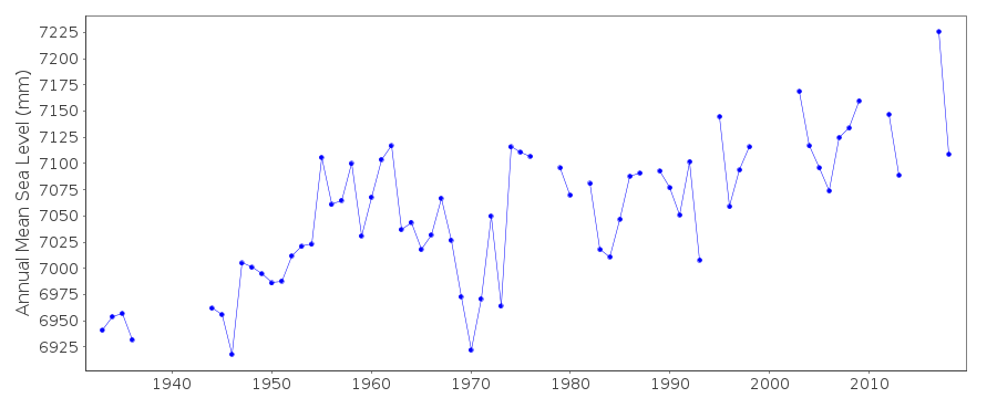
| Time span of data: | 1932 – 2025 |
| Completeness (%): | 80 |
| Link to ellipsoid: | Available |
| Date of last update: | 27 Jan 2026 |
| Green Arrow: | Current Station |
| Yellow Marker: | Neighbouring RLR Station |
| Red Marker: | Neighbouring Metric Station |
Please note: In many cases, the station position in our database is accurate to only one minute. Thus, the tide gauge may not appear to be on the coast.
Tide Gauge Data
Additional Data Sources (guide to additional data sources)
Nearby GNSS Stations from SONEL: BRSG, BRMUNearby Real Time Stations from VLIZ: bmda, bbst2, bbst
Fast Delivery Data from UHSLC station 259: hourly and daily
Research Quality Data from UHSLC station 259: hourly and daily
Station Documentation
Link to RLR information.Documentation added 1991-06-11
St Georges 950/011 RLR(1964) is 8.4m below BM1Documentation added 1994-11-30
station at Biological station discontinued and replaced by station at Esso PierDocumentation added 2011-12-08
BM1 was an old mark that no longer exists. Benchmark 5535 H 1978 2.445m above station datum was the Primary benchmark for the Bermuda Biological Station gauge. Benchmark 5540 A 1979 is the Primary benchmark for the Esso Pier tide gauge. From the NOAA website is the following warning 'Benchmarks 5535 F 1978 and 5535 H 1978 are based on one differential levelling connection and do not meet the quality control standards of NOS. Therefore, caution should be used when deriving elevations for these marks'.Data Authority
N.O.A.A. / N.O.S.N/oes33, Ssmc4, Room 6531
1305 East-West Highway
Silver Spring,
MD 20910

![]()
![]()
![]()
