Data
- Obtaining
- Supplying
- High-Frequency
- Bottom Pressure Records
- Other Long Records
- GLOSS/ODINAFRICA Calibration Data
Donate
Donate to PSMSL
Data Notes
- Individual Station Data and Plot Notes
- Referencing the Data Set
- PSMSL Help File
- 2010 Changes to the PSMSL Data Files
Extracted from Database
03 Mar 2025
Station Information
| Station ID: | 373 |
| Latitude: | 40.632542 |
| Longitude: | 22.934933 |
| Coastline code: | 290 |
| Station code: | 51 |
| Country: | GREECE |
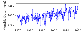
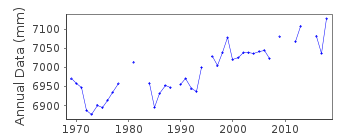
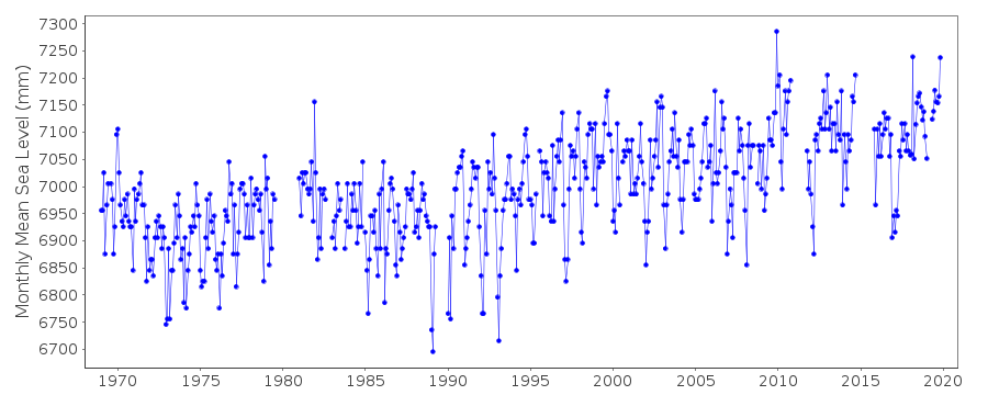
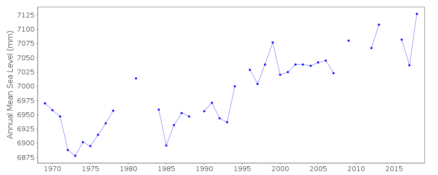
| Time span of RLR data: | 1969 – 2019 |
| RLR completeness (%): | 89 |
| Time span of metric data: | 1933 – 2019 |
| Metric completeness (%): | 62 |
| Date of last update: | 15 Oct 2020 |
| Green Arrow: | Current Station |
| Yellow Marker: | Neighbouring RLR Station |
| Red Marker: | Neighbouring Metric Station |
Please note: In many cases, the station position in our database is accurate to only one minute. Thus, the tide gauge may not appear to be on the coast.
Tide Gauge Data
Station Documentation
Link to RLR information.Documentation added 1991-06-11
Thessaloniki 290/051 RLR(1981) is 9.2m below BM R16Documentation added 1993-07-12
Thessaloniki 290/051 RLR(1981) is 9.2m below BM R16Documentation added 2006-11-28
Whole dataset flagged due to unresolved datum query.Documentation added 2008-04-09
Since the change in the method of sea level recording frommeasuring downwards to the usual measuring upwards the tidal
plot for Thessalonika had appeared in error as there seemed
to be a large upwards jump. Following lengthy correspondence
with the HNHS it transpires that following a datum control
and levelling exercise a correction of +0.34m was applied
to the TGZ. When this correction was applied the data
plot appears to be OK.See Greek letter in reply to the letter of 26th March 2007.
Documentation added 2013-08-13
The Hellenic Navy have recently supplied datum diagrams for each of there stations. Previously used benchmark R 16 does not appear on the new diagram. In consequence the RLR diagram has been re-drawn using benchmark R. As a result the RLR factors have changed.Data Authority
Hellenic Navy Hydrographic ServiceGeographic Policy and International Relations Office
TGN 1040
Athens

![]()
![]()
![]()
