Data
- Obtaining
- Supplying
- High-Frequency
- Bottom Pressure Records
- Other Long Records
- GLOSS/ODINAFRICA Calibration Data
Donate
Donate to PSMSL
Data Notes
- Individual Station Data and Plot Notes
- Referencing the Data Set
- PSMSL Help File
- 2010 Changes to the PSMSL Data Files
Extracted from Database
03 Mar 2025
Station Information
| Station ID: | 397 |
| Latitude: | 54.510833 |
| Longitude: | 13.643056 |
| Coastline code: | 120 |
| Station code: | 4 |
| Country: | GERMANY |
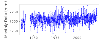
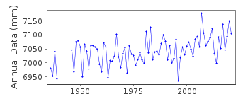
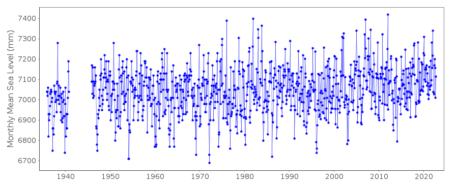
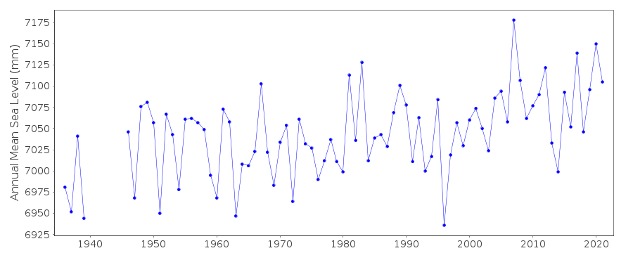
| Time span of data: | 1935 – 2024 |
| Completeness (%): | 93 |
| Link to ellipsoid: | Available |
| Date of last update: | 11 Jul 2024 |
| Green Arrow: | Current Station |
| Yellow Marker: | Neighbouring RLR Station |
| Red Marker: | Neighbouring Metric Station |
Please note: In many cases, the station position in our database is accurate to only one minute. Thus, the tide gauge may not appear to be on the coast.
Tide Gauge Data
Additional Data Sources (guide to additional data sources)
Nearby GNSS Stations from SONEL: SAS2, SASSNearby Real Time Stations from VLIZ: sass
Station Documentation
Link to RLR information.Documentation added 1992-07-09
Gauges in Eastern Germany (Wismar, Warnemunde, Sassnitz, Koserow) as of March 1992 are type 'Steremat', vertical drum , swimmer principle Measures 1:10, continuous registration on paper chart, information from L. Ballani, PotsdamDocumentation added 2002-01-29
The Sassnitz data from 1936-1977 are the so-called 'Lindner values' measured with respect to Pegelnull (PN) = 5000 mm below NN. Data were supplied by authority Wasserwirtschaftsdirektion Kuste of the former DDR). They were derived mostly from once per day values as follows:JAN 36 - FEB 52 ONCE PER DAY AT 1200; MAR 52 - JUN 52 AT 1300;
JUL 52 - OCT 55 AT 0800; NOV 55 - OCT 59 FROM SO CALLED
Approximated daily mean; NOV 59 - OCT 80 AT 0700 (information from L.Ballani, Potsdam March 1992).
The location in this period was said to be 54 32N 13 40 E. The data for 1978-87 were obtained from authority Geoforschungszentrum Potsdam) based on 24 readings per day. Data for 1992- were obtained from BSH, Germany based on 24 readings per day.
Documentation added 2002-01-29
Sassnitz 120/004 RLR(2002) is 45.908m below BM 4.052.13.1321Documentation added 2010-08-09
The data for Sassnitz 1936-1977 was measured to PN datum (PN=HN-514cm.) Data from 1978-1987 referred to datum HN76. It is unusual for a station such as this to be made RLR as it 'breaks the rules' of RLR. Data now refers to TGZ.Data Authority
Bundesamt fur Seeschifffahrt und Hydrographie HamburgBernhard-Nocht-Strasse 78
20359 Hamburg
Documentation added 1993-10-05
FORMERLY THE DEUTSCHES HYDROGRAPHISCHES INSTITUT

![]()
![]()
![]()
