Data
- Obtaining
- Supplying
- High-Frequency
- Bottom Pressure Records
- Other Long Records
- GLOSS/ODINAFRICA Calibration Data
Donate
Donate to PSMSL
Data Notes
- Individual Station Data and Plot Notes
- Referencing the Data Set
- PSMSL Help File
- 2010 Changes to the PSMSL Data Files
Extracted from Database
03 Mar 2025
Station Information
| Station ID: | 413 |
| Latitude: | 51.233333 |
| Longitude: | 2.916667 |
| Coastline code: | 160 |
| Station code: | 21 |
| Country: | BELGIUM |
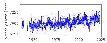
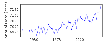
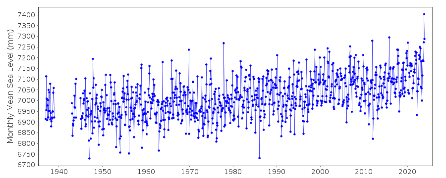
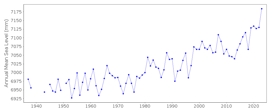
| Time span of data: | 1937 – 2024 |
| Completeness (%): | 94 |
| Date of last update: | 15 Jan 2025 |
| Green Arrow: | Current Station |
| Yellow Marker: | Neighbouring RLR Station |
| Red Marker: | Neighbouring Metric Station |
Please note: In many cases, the station position in our database is accurate to only one minute. Thus, the tide gauge may not appear to be on the coast.
Tide Gauge Data
Additional Data Sources (guide to additional data sources)
Nearby GNSS Stations from SONEL: OOST, OSTENearby Real Time Stations from VLIZ: oste, oste1
Station Documentation
Link to RLR information.Documentation added 2000-02-25
Oostende 160/021 RLR(1974) is 11.4m below BM DH4-IIDocumentation added 2011-09-05
There seems to have been some confusion regarding the RLR factor for Ostend following the introduction of the TAW datum in 1981. Previously RLR factor 4.730m was added to the data. From the correspondence file this now appears in error, from 1981 data onwards the RLR factor has been reset to 4.733m, the data have been adjusted.Documentation added 2012-07-19
While preparing the 2010 data values for entry it was noticed that on occasion the non Doodson filtered data values had been entered for 2008/9. These values were replaced with the Doodson filtered values.Data Authority
Agency for Maritime and Coastal ServicesFlemish Hydrography
Vrijhavenstraat 3
8400 Oostende
Documentation added 2008-12-10
This authority was formerly calledAfdeling Waterwegen Kust.

![]()
![]()
![]()
