Data
- Obtaining
- Supplying
- High-Frequency
- Bottom Pressure Records
- Other Long Records
- GLOSS/ODINAFRICA Calibration Data
Donate
Donate to PSMSL
Data Notes
- Individual Station Data and Plot Notes
- Referencing the Data Set
- PSMSL Help File
- 2010 Changes to the PSMSL Data Files
Extracted from Database
13 Jul 2026
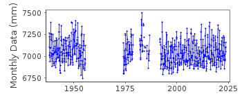
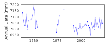
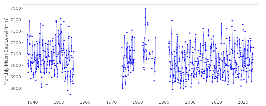
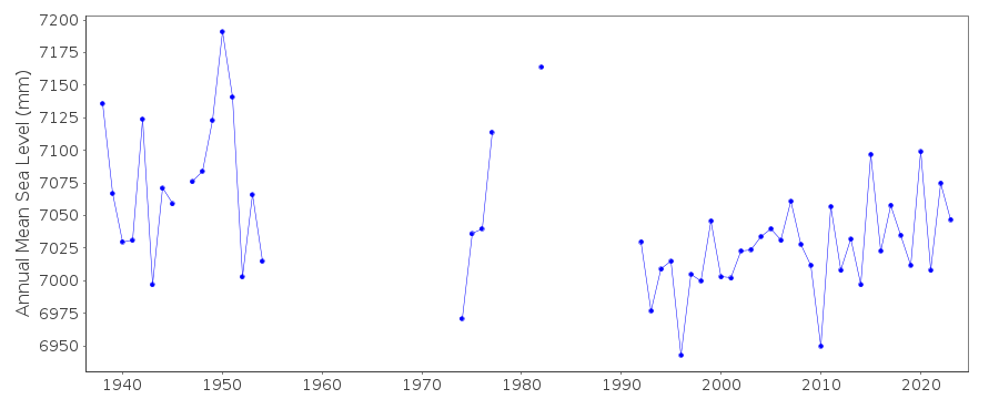
Station Information
| Station ID: | 425 |
| Latitude: | 69.326067 |
| Longitude: | 16.134848 |
| GLOSS ID: | 322 |
| Coastline code: | 40 |
| Station code: | 41 |
| Country: | NORWAY |
| Time span of data: | 1938 – 2025 |
| Completeness (%): | 67 |
| Date of last update: | 30 Jan 2026 |
| Green Arrow: | Current Station |
| Yellow Marker: | Neighbouring RLR Station |
| Red Marker: | Neighbouring Metric Station |
Please note: In many cases, the station position in our database is accurate to only one minute. Thus, the tide gauge may not appear to be on the coast.
Tide Gauge Data
Additional Data Sources (guide to additional data sources)
Nearby GNSS Stations from SONEL: AND1Nearby Real Time Stations from VLIZ: ande
Fast Delivery Data from UHSLC station 800: hourly and daily
Research Quality Data from UHSLC station 800: hourly and daily
Station Documentation
Link to RLR information.Documentation added 1991-06-11
Andenes 040/041 RLR(1955) is 7.3m below FM AndenesIDocumentation added 1993-07-12
Andenes 040/041 RLR(1955) is 7.3m below FM AndenesIDocumentation added 1993-10-06
DATA UP TO 1986 FROM AUTHORITY CODE 03Documentation added 1995-03-30
tide gauge network modernised, new equipment installed in 1991Documentation added 2009-04-06
2007/8 mean sea level values entered as METRIC only awaiting confirmation of a datum query.Documentation added 2010-07-19
The Norwegian Mapping Authority has revised all its datasets. The Primary bench mark for Andenes from 1991 onwards is L7 N42which is 5.245m above TGZ (See copy of the page for Andenes from the Norwegian website with the RLR diagram). RLR has been re-calculated using 2008 as the RLR year. Revised RLR factor is now 5.055m from 1991 data onwards. RLR (2008) is 10.3m below TGBM L7 N42.Documentation added 2012-09-05
For information on sea level change along the Norwegian coast see paper "Contributions to sea level variability along the Norwegian coast for 1960-2010" by K.Richter, J.E.O. Nilsen and H. Drange.Data Authority
Norwegian Mapping AuthorityHydrographic Service
Po. Box 60
4001 Stavanger

![]()
![]()
![]()
