Data
- Obtaining
- Supplying
- High-Frequency
- Bottom Pressure Records
- Other Long Records
- GLOSS/ODINAFRICA Calibration Data
Donate
Donate to PSMSL
Data Notes
- Individual Station Data and Plot Notes
- Referencing the Data Set
- PSMSL Help File
- 2010 Changes to the PSMSL Data Files
Extracted from Database
03 Mar 2025
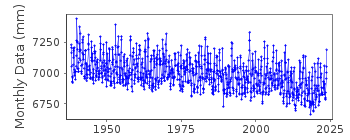
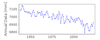
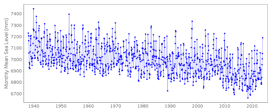
Station Information
| Station ID: | 426 |
| Latitude: | 57.051667 |
| Longitude: | -135.341667 |
| GLOSS ID: | 154 |
| Coastline code: | 821 |
| Station code: | 31 |
| Country: | UNITED STATES |
| Time span of data: | 1938 – 2024 |
| Completeness (%): | 100 |
| Date of last update: | 23 Jan 2025 |
| Green Arrow: | Current Station |
| Yellow Marker: | Neighbouring RLR Station |
| Red Marker: | Neighbouring Metric Station |
Please note: In many cases, the station position in our database is accurate to only one minute. Thus, the tide gauge may not appear to be on the coast.
Tide Gauge Data
Additional Data Sources (guide to additional data sources)
Nearby GNSS Stations from SONEL: AKSINearby Real Time Stations from VLIZ: sitk, sitk2
Fast Delivery Data from UHSLC station 559: hourly and daily
Research Quality Data from UHSLC station 559: hourly and daily
Station Documentation
Link to RLR information.Documentation added 1991-06-11
Sitka 821/031 RLR(1964) is 9.5m below BM8Documentation added 1992-04-02
SOUTH ALASKAN COASTLINE EARTHQUAKE PRONE - E.G. MAGNITUDE 9.2 EARTHQUAKE OF 28 MARCH 1964 - SEE SAVAGE AND PLAFKER, JGR, 96(B3), 4325-4335, 1991Documentation added 1994-07-15
Pugh, 1987 (Tides, surges and mean sea-level. Wiley) refers to a magnitude 7.1 earthquake in July 1972, centred 40km off-shore of Sitka, which apparently had no effect on the tide gauge record.Documentation added 2011-11-23
Using information from the NOAA website the RLR diagram has been revised. Previous Primary benchmark BM 8 - named 8 1924 on the NOAA site appears in the 1984 report with a value of 5.518m relative to gauge datum but does not appear in the 2003 report. Current Primary benchmark is 1600 L 1982 with a value of 13.669m above gauge datum.Data Authority
N.O.A.A. / N.O.S.N/oes33, Ssmc4, Room 6531
1305 East-West Highway
Silver Spring,
MD 20910

![]()
![]()
![]()
