Data
- Obtaining
- Supplying
- High-Frequency
- Bottom Pressure Records
- Other Long Records
- GLOSS/ODINAFRICA Calibration Data
Donate
Donate to PSMSL
Data Notes
- Individual Station Data and Plot Notes
- Referencing the Data Set
- PSMSL Help File
- 2010 Changes to the PSMSL Data Files
Extracted from Database
03 Mar 2025
Station Information
| Station ID: | 432 |
| Latitude: | 53.35 |
| Longitude: | -6.216667 |
| Coastline code: | 175 |
| Station code: | 71 |
| Country: | IRELAND |
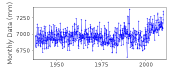
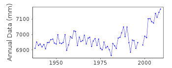
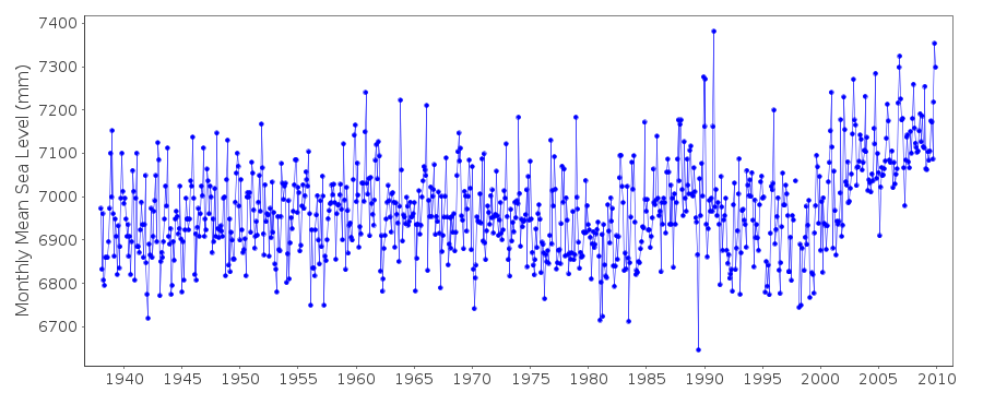
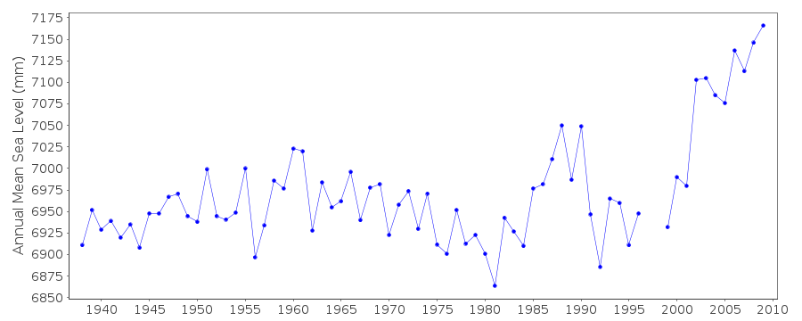
| Time span of data: | 1938 – 2009 |
| Completeness (%): | 99 |
| MTL Data: | 1938-2001 |
| MTL-MSL (mm): | Not Applied |
| Date of last update: | 15 Mar 2017 |
| Green Arrow: | Current Station |
| Yellow Marker: | Neighbouring RLR Station |
| Red Marker: | Neighbouring Metric Station |
Please note: In many cases, the station position in our database is accurate to only one minute. Thus, the tide gauge may not appear to be on the coast.
Tide Gauge Data
Additional Data Sources (guide to additional data sources)
Nearby GNSS Stations from SONEL: TLL1, TLLGStation Documentation
Link to RLR information.Documentation - date unknown
DATUM CHANGED FROM PORT DATUM TO L.A.T. ON 1/1/78; L.A.T. IS 0.23M BELOW PORT DATUMDocumentation added 1991-06-11
Dublin 175/071 RLR(1987) is 10.6m below TGBM Estabished 1895Documentation added 2010-06-10
Up until 2001 the data for Dublin was sent on a regular basis to POL by the Dublin Port Company datum at that time was referred to L.A.T.. However in 2002 the Hydrographic Department closed down and although the gauge is still running and the records kept by the Harbour Master Capt. David Dignam he has assumed the datum to be chart datum. Capt. Dignam has supplied the high frequency data for 2002-2009 which has now been processed.Documentation added 2017-03-15
After examining the historical files it was discovered that data for Dublin up to 2001 was supplied as Mean Tide Data and not Mean Sea Level data. Because of this the data has been flagged within the database.Documentation added 2018-08-08
Gerard McCarthy has supplied a map confirming that the tide gauge at Dublin was situated in the Alexander Basin.Data Authority
Dublin Port CompanyPort Centre
Alexandra Road
Dublin 1
Documentation added 2002-07-08
The Dublin Port Company was formerly the Dublin Port &Docks Board.

![]()
![]()
![]()
