Data
- Obtaining
- Supplying
- High-Frequency
- Bottom Pressure Records
- Other Long Records
- GLOSS/ODINAFRICA Calibration Data
Donate
Donate to PSMSL
Data Notes
- Individual Station Data and Plot Notes
- Referencing the Data Set
- PSMSL Help File
- 2010 Changes to the PSMSL Data Files
Extracted from Database
03 Mar 2025
Station Information
| Station ID: | 434 |
| Latitude: | -34.966667 |
| Longitude: | -54.95 |
| Coastline code: | 870 |
| Station code: | 21 |
| Country: | URUGUAY |
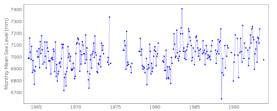
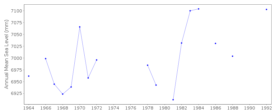
| Time span of RLR data: | 1964 – 1993 |
| RLR completeness (%): | 79 |
| Time span of metric data: | 1938 – 1993 |
| Metric completeness (%): | 57 |
| Date of last update: | 23 May 1996 |
| Green Arrow: | Current Station |
| Yellow Marker: | Neighbouring RLR Station |
| Red Marker: | Neighbouring Metric Station |
Please note: In many cases, the station position in our database is accurate to only one minute. Thus, the tide gauge may not appear to be on the coast.
Tide Gauge Data
Station Documentation
Link to RLR information.Documentation added 1991-06-11
Punta del Este 870/021 RLR(1964) is 11.5m below BM SH PrefecturaDocumentation added 1993-07-12
Punta del Este 870/021 RLR(1964) is 11.5m below BM SH PrefecturaPunta del Este is an historic station last data 1993
Data Authority
SOHMA (Oceanographic, Hydrography andMeteorology Service of the Uruguayan Navy)
Capurro 980
MONTEVIDEO

![]()
![]()
![]()
