Data
- Obtaining
- Supplying
- High-Frequency
- Bottom Pressure Records
- Other Long Records
- GLOSS/ODINAFRICA Calibration Data
Donate
Donate to PSMSL
Data Notes
- Individual Station Data and Plot Notes
- Referencing the Data Set
- PSMSL Help File
- 2010 Changes to the PSMSL Data Files
Extracted from Database
03 Mar 2025
Station Information
| Station ID: | 44 |
| Latitude: | 12.788333 |
| Longitude: | 44.974167 |
| GLOSS ID: | 3 |
| Coastline code: | 485 |
| Station code: | 1 |
| Country: | YEMEN |
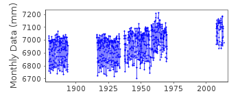
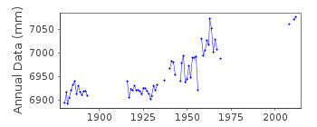
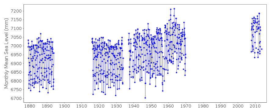
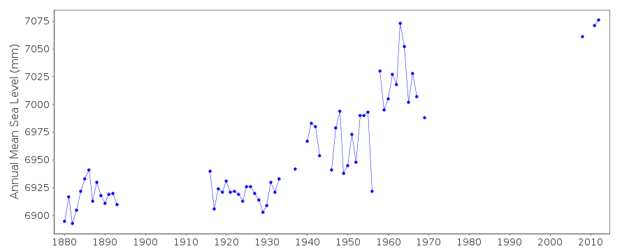
| Time span of data: | 1879 – 2013 |
| Completeness (%): | 50 |
| MTL Data: | 1937-1956 |
| MTL-MSL (mm): | 16 |
| Date of last update: | 01 Feb 2016 |
| Green Arrow: | Current Station |
| Yellow Marker: | Neighbouring RLR Station |
| Red Marker: | Neighbouring Metric Station |
Please note: In many cases, the station position in our database is accurate to only one minute. Thus, the tide gauge may not appear to be on the coast.
Tide Gauge Data
Additional Data Sources (guide to additional data sources)
Fast Delivery Data from UHSLC station 172: hourly and dailyResearch Quality Data from UHSLC station 172: hourly and daily
Station Documentation
Link to RLR information.Documentation - date unknown
1937 - 1956 VALUES BASED ON HIGH AND LOW WATER READINGSDocumentation added 1991-06-11
Aden 485/001 RLR(1962) is 9.1m below BM PEODocumentation added 2009-03-10
2007/8 one minute sea level data downloaded from the IOC Sea Level Station Monitoring Facility Ostend. This is then converted to 15min. data for processing. 2008 monthly and annual mean sea level values have now been extracted from the data. As the relationship for the prime bench mark remains the same there is no need to alter RLR. Details of the bench marks has been derived from site installation information. Copies of these have been included in the port files and RLR file for reference.Documentation added 2013-09-11
The historic data for Aden (1879-1933) has been reviewed. As a result the RLR factor for all of that period has been set to 5.141mDocumentation added 2016-01-22
A value of MTL-MSL=16 mm has been applied to the RLR data for the period 1937-1956 using harmonic constituents from the GESLA2 (high-frequency tide gauge) dataset.Data Authority
Aden Port AuthorityTawahi
Aden

![]()
![]()
![]()
