Data
- Obtaining
- Supplying
- High-Frequency
- Bottom Pressure Records
- Other Long Records
- GLOSS/ODINAFRICA Calibration Data
Donate
Donate to PSMSL
Data Notes
- Individual Station Data and Plot Notes
- Referencing the Data Set
- PSMSL Help File
- 2010 Changes to the PSMSL Data Files
Extracted from Database
03 Mar 2025
Station Information
| Station ID: | 446 |
| Latitude: | 7.833333 |
| Longitude: | 98.433333 |
| GLOSS ID: | 42 |
| Coastline code: | 545 |
| Station code: | 1 |
| Country: | THAILAND |
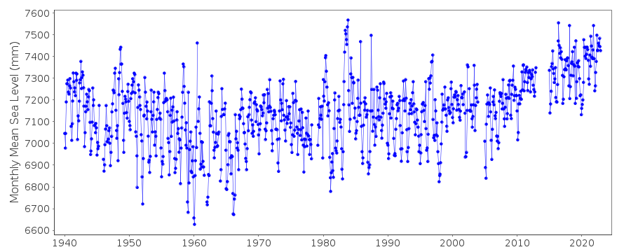
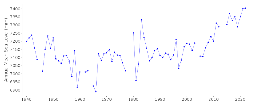
| Time span of data: | 1940 – 2023 |
| Completeness (%): | 94 |
| Date of last update: | 08 Jul 2024 |
| Green Arrow: | Current Station |
| Yellow Marker: | Neighbouring RLR Station |
| Red Marker: | Neighbouring Metric Station |
Please note: In many cases, the station position in our database is accurate to only one minute. Thus, the tide gauge may not appear to be on the coast.
Tide Gauge Data

Additional Data Sources (guide to additional data sources)
Fast Delivery Data from UHSLC station 148: hourly and dailyResearch Quality Data from UHSLC station 148: hourly and daily
Station Documentation
Link to RLR information.Documentation added 1991-06-11
Ko Taphao Noi 545/001 RLR(1981) is 9.8m below BM S.I.Documentation added 2011-07-12
While checking datum and benchmark information prior to the uploading of the RLR diagram onto the website the following information was discovered. From 1987 onwards the benchmark was BM 105 5.429m above the 1940-1987 datum. In 1988 the datum was raised 14mm. BM 105 then became 5.415m above the revised 1988 datum. In 1998 the primary benchmark became AS-1/2531 5.304m relative to the 1988 datum.Data Authority
Oceanographic DivisionHydrographic Department
Royal Thai Navy
222 Rimtang-Rodfai-kao Road
Bangna, Bangkok 10260

![]()
![]()
![]()
