Data
- Obtaining
- Supplying
- High-Frequency
- Bottom Pressure Records
- Other Long Records
- GLOSS/ODINAFRICA Calibration Data
Donate
Donate to PSMSL
Data Notes
- Individual Station Data and Plot Notes
- Referencing the Data Set
- PSMSL Help File
- 2010 Changes to the PSMSL Data Files
Extracted from Database
03 Mar 2025
Station Information
| Station ID: | 468 |
| Latitude: | 51.048091 |
| Longitude: | 2.366698 |
| Coastline code: | 190 |
| Station code: | 1 |
| Country: | FRANCE |
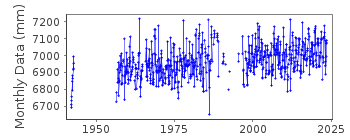
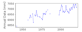
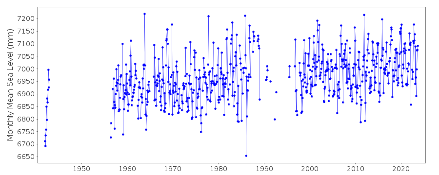
| Time span of data: | 1942 – 2023 |
| Completeness (%): | 69 |
| Link to ellipsoid: | Available |
| Date of last update: | 30 Jan 2024 |
| Green Arrow: | Current Station |
| Yellow Marker: | Neighbouring RLR Station |
| Red Marker: | Neighbouring Metric Station |
Please note: In many cases, the station position in our database is accurate to only one minute. Thus, the tide gauge may not appear to be on the coast.
Tide Gauge Data
Additional Data Sources (guide to additional data sources)
Nearby GNSS Stations from SONEL: DUNQ, COUD, DGLGNearby Real Time Stations from VLIZ: dunk, dunk2
Station Documentation
Link to RLR information.Documentation - date unknown
1942 data supplied by B.O.D.C.Documentation added 1991-06-11
Dunkerque 190/001 RLR(1977) is 13.2m below Repere A(1974)Documentation added 2000-10-19
Dunkerque acoustic gauge installed 1998. Data now supplied by Service Hydrographique et Ocean. de la Marine, Brest.Documentation added 2014-09-24
Using values from the SONEL website the latitude and longitude for Dunkerque have been revised.Documentation added 2014-09-29
Additional data points have been added. Because of this the whole dataset has been re-entered.Data Authority
SHOM13 rue de Chatelier
29200 BREST

![]()
![]()
![]()
