Data
- Obtaining
- Supplying
- High-Frequency
- Bottom Pressure Records
- Other Long Records
- GLOSS/ODINAFRICA Calibration Data
Donate
Donate to PSMSL
Data Notes
- Individual Station Data and Plot Notes
- Referencing the Data Set
- PSMSL Help File
- 2010 Changes to the PSMSL Data Files
Extracted from Database
03 Mar 2025
Station Information
| Station ID: | 469 |
| Latitude: | 43.395239 |
| Longitude: | -1.681623 |
| Coastline code: | 190 |
| Station code: | 141 |
| Country: | FRANCE |
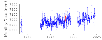
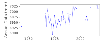
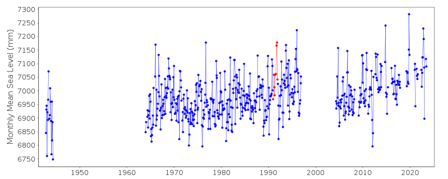
| Time span of RLR data: | 1942 – 2023 |
| RLR completeness (%): | 56 |
| Time span of metric data: | 1942 – 2023 |
| Metric completeness (%): | 61 |
| Link to ellipsoid: | Available |
| Date of last update: | 30 Jan 2024 |
| Green Arrow: | Current Station |
| Yellow Marker: | Neighbouring RLR Station |
| Red Marker: | Neighbouring Metric Station |
Please note: In many cases, the station position in our database is accurate to only one minute. Thus, the tide gauge may not appear to be on the coast.
Tide Gauge Data
Additional Data Sources (guide to additional data sources)
Nearby GNSS Stations from SONEL: SCOANearby Real Time Stations from VLIZ: scoa, scoa2
Station Documentation
Link to RLR information.Documentation - date unknown
1942-1944 Data supplied by B.O.D.C.1960-1963 Data supplied by National Geographical Institute, France
Documentation added 1991-06-11
St Jean-de-Luz 190/141 RLR(1979) is 9.9m below RepereA(1976)Documentation added 1993-07-22
height shift of approx 15cm in May 1991Documentation added 2012-04-04
Title of the station has been changed from Socoa/ St. Jean de Luz to St. John de Luz (Socoa). Primary benchmark is now IGN no O.A.K3L3-4 II 7.975m above TGZ.Documentation added 2023-02-07
Recent investigations have indicated that the 1942-1944 data come from a wartime German installation from the other side of the Socoa bay. The data are consistent with the rest of the record based on tidal analysis. See "Extension of high temporal resolution sea level time series at Socoa(Saint Jean-de-Luz, France) back to 1875", https://doi.org/10.5194/essd-2022-443
Data Authority
SHOM13 rue de Chatelier
29200 BREST

![]()
![]()
![]()
