Data
- Obtaining
- Supplying
- High-Frequency
- Bottom Pressure Records
- Other Long Records
- GLOSS/ODINAFRICA Calibration Data
Donate
Donate to PSMSL
Data Notes
- Individual Station Data and Plot Notes
- Referencing the Data Set
- PSMSL Help File
- 2010 Changes to the PSMSL Data Files
Extracted from Database
03 Mar 2025
WARNING: QCFLAG EXISTS. PLEASE READ THE DOCUMENTATION.
Station Information
| Station ID: | 487 |
| Latitude: | 51.863333 |
| Longitude: | -176.631667 |
| GLOSS ID: | 302 |
| Coastline code: | 820 |
| Station code: | 11 |
| Country: | UNITED STATES |
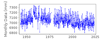
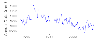
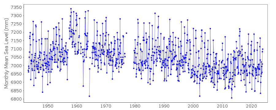
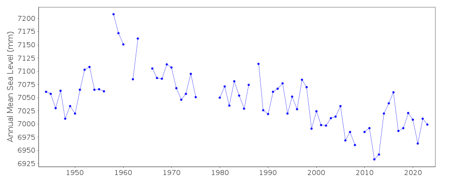
| Time span of data: | 1943 – 2024 |
| Completeness (%): | 92 |
| Date of last update: | 23 Jan 2025 |
| Green Arrow: | Current Station |
| Yellow Marker: | Neighbouring RLR Station |
| Red Marker: | Neighbouring Metric Station |
Please note: In many cases, the station position in our database is accurate to only one minute. Thus, the tide gauge may not appear to be on the coast.
Tide Gauge Data
Additional Data Sources (guide to additional data sources)
Nearby GNSS Stations from SONEL: AB21Nearby Real Time Stations from VLIZ: adak, adak2
Fast Delivery Data from UHSLC station 40: hourly and daily
Research Quality Data from UHSLC station 40: hourly and daily
Station Documentation
Link to RLR information.Documentation added 1991-06-11
Adak 820/011 RLR(1985) is 12.2m below BM 18Documentation added 1993-07-12
Apparent shifts at data gaps in the late 1950s and early 1960s.Documentation added 2011-11-23
Using information from the NOAA website the RLR diagram was revised. Primary benchmark is still 18 1957 - named NO 18 1957 on the NOAA website 6.7m above gauge datum.Data Authority
N.O.A.A. / N.O.S.N/oes33, Ssmc4, Room 6531
1305 East-West Highway
Silver Spring,
MD 20910

![]()
![]()
![]()
