Data
- Obtaining
- Supplying
- High-Frequency
- Bottom Pressure Records
- Other Long Records
- GLOSS/ODINAFRICA Calibration Data
Donate
Donate to PSMSL
Data Notes
- Individual Station Data and Plot Notes
- Referencing the Data Set
- PSMSL Help File
- 2010 Changes to the PSMSL Data Files
Extracted from Database
03 Mar 2025
Station Information
| Station ID: | 497 |
| Latitude: | 26.06 |
| Longitude: | -97.215 |
| Coastline code: | 940 |
| Station code: | 1 |
| Country: | UNITED STATES |
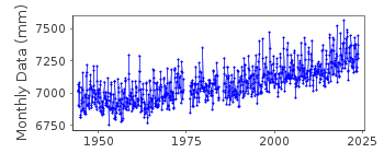
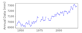
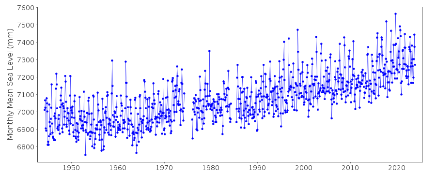
| Time span of data: | 1944 – 2024 |
| Completeness (%): | 96 |
| Date of last update: | 23 Jan 2025 |
| Green Arrow: | Current Station |
| Yellow Marker: | Neighbouring RLR Station |
| Red Marker: | Neighbouring Metric Station |
Please note: In many cases, the station position in our database is accurate to only one minute. Thus, the tide gauge may not appear to be on the coast.
Tide Gauge Data
Additional Data Sources (guide to additional data sources)
Nearby GNSS Stations from SONEL: TXLNResearch Quality Data from UHSLC station 772: hourly and daily
Station Documentation
Link to RLR information.Documentation added 1991-06-11
Port Isabel 940/001 RLR(1970) is 9.0m below BM6Documentation added 1993-07-29
Many stations on the Gulf coast have large values for September 1961.Documentation added 2011-07-27
The data was downloded from the NOAA site. Datum information was also extracted. The NOAA Primary Benchmark is now NO 10 1973 4.276 above TGZ.Documentation added 2014-02-13
Whole dataset was downloaded from NOAA. There were data point revised throughout 1971-1972 and 1977-1995. Adjustments were in the order of 2-3mm. Datum level for Sept. 2011 - Oct. 2012 was also adjusted.Data Authority
N.O.A.A. / N.O.S.N/oes33, Ssmc4, Room 6531
1305 East-West Highway
Silver Spring,
MD 20910

![]()
![]()
![]()
