Data
- Obtaining
- Supplying
- High-Frequency
- Bottom Pressure Records
- Other Long Records
- GLOSS/ODINAFRICA Calibration Data
Donate
Donate to PSMSL
Data Notes
- Individual Station Data and Plot Notes
- Referencing the Data Set
- PSMSL Help File
- 2010 Changes to the PSMSL Data Files
Extracted from Database
03 Mar 2025
WARNING: QCFLAG EXISTS. PLEASE READ THE DOCUMENTATION.
Station Information
| Station ID: | 499 |
| Latitude: | -33.027222 |
| Longitude: | -71.625833 |
| GLOSS ID: | 175 |
| Coastline code: | 850 |
| Station code: | 31 |
| Country: | CHILE |
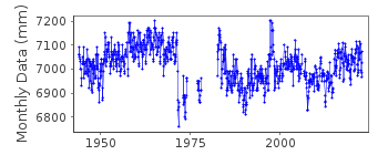
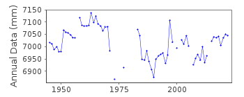
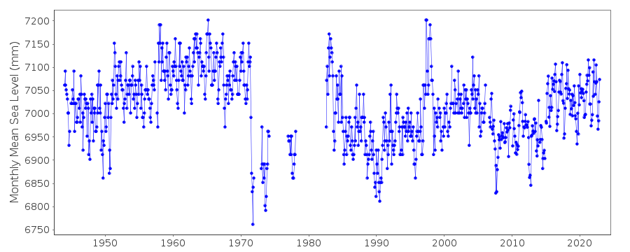
| Time span of data: | 1944 – 2023 |
| Completeness (%): | 88 |
| Date of last update: | 07 May 2024 |
| Green Arrow: | Current Station |
| Yellow Marker: | Neighbouring RLR Station |
| Red Marker: | Neighbouring Metric Station |
Please note: In many cases, the station position in our database is accurate to only one minute. Thus, the tide gauge may not appear to be on the coast.
Tide Gauge Data
Additional Data Sources (guide to additional data sources)
Nearby GNSS Stations from SONEL: VALP, VALN, TRPDNearby Real Time Stations from VLIZ: valp, valp2
Fast Delivery Data from UHSLC station 81: hourly and daily
Research Quality Data from UHSLC station 81: hourly and daily
Station Documentation
Link to RLR information.Documentation added 1991-06-11
Valparaiso 850/031 RLR(1990) is 11.0m below BM DHN No 2Documentation added 1993-07-29
Record full of unexplained datum shifts.Documentation added 1996-01-03
There was a magnitude 7.8 earthquake about 20 km offshore of northern Chile on 30 July 1995 which produced a tsunami of 1.3 m at Caldera and which was seen in many records across the Pacific (information from NTF, Australia).Documentation added 2004-10-20
Data for the period 1944-91 were replaced by a new data set received from authority (57)Documentation added 2011-11-16
An earthquake registering 8.8 on the Moment Magnitude Scale occurred off the coast of Central Chile on 27.2.2010 at 03.34 local time (06.34UTC).Data Authority
Hydrographic and Oceanographic Service of the Chilean NavyErrazuriz 254
Playa Ancha
Valparaiso

![]()
![]()
![]()
