Data
- Obtaining
- Supplying
- High-Frequency
- Bottom Pressure Records
- Other Long Records
- GLOSS/ODINAFRICA Calibration Data
Donate
Donate to PSMSL
Data Notes
- Individual Station Data and Plot Notes
- Referencing the Data Set
- PSMSL Help File
- 2010 Changes to the PSMSL Data Files
Extracted from Database
03 Mar 2025
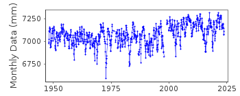
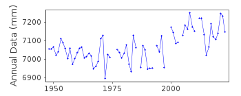
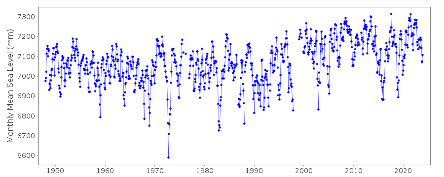
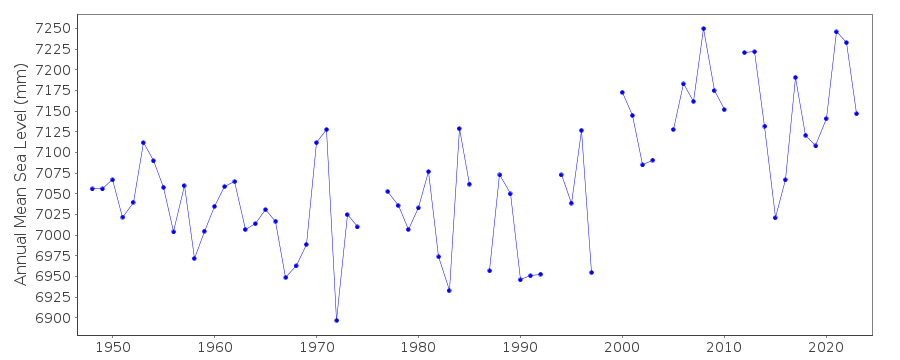
Station Information
| Station ID: | 540 |
| Latitude: | 13.438333 |
| Longitude: | 144.653333 |
| GLOSS ID: | 149 |
| Coastline code: | 701 |
| Station code: | 1 |
| Country: | GUAM |
| Time span of data: | 1948 – 2023 |
| Completeness (%): | 95 |
| Date of last update: | 26 Jan 2024 |
| Green Arrow: | Current Station |
| Yellow Marker: | Neighbouring RLR Station |
| Red Marker: | Neighbouring Metric Station |
Please note: In many cases, the station position in our database is accurate to only one minute. Thus, the tide gauge may not appear to be on the coast.
Tide Gauge Data
Additional Data Sources (guide to additional data sources)
Nearby GNSS Stations from SONEL: OGU2, GUUGNearby Real Time Stations from VLIZ: guam2, guam
Fast Delivery Data from UHSLC station 53: hourly and daily
Research Quality Data from UHSLC station 53: hourly and daily
Station Documentation
Link to RLR information.Documentation added 1995-04-27
Station recoded as 701/001 on 27th April 1995 (was 700/001)Documentation added 1995-07-31
Guam 701/001 RLR(1964) is 9.3m below BM1Documentation added 1995-07-31
Station is at Apra Harbor.Documentation added 2002-10-16
Guam - suspected land movement of 2-3cm in 1993 following earthquake.Documentation added 2011-07-18
The operators of the Guam tide gauge, Center for Operational Oceanographic Products and Services (CO-OPS) part of NOAA note that a change in the sea level trend occurs after the 1993 Guam earthquake. The stability of the tide gauge datum for the post earthquake is therefore a concern.CO-OPS continue to monitor the site.Documentation added 2011-11-23
Using information from the NOAA website the RLR diagram has been revised. Previous Primary benchmark BM 1 no longer appears in the NOAA reports. Primary benchmark NO 4 1949 2.996m above gauge datum appears on the original RLR diagram as a secondary benchmark.Documentation added 2018-04-24
Comparisons of Guam tide gauge sea levels to those from satellite altimetry have shown that the apparentchanges in level around 1993 and 1999 seen in the annual MSL record are similar to those also seen in altimeter data. Therefore, although Guam does experience earthquakes and occasional changes in land level due to earthquakes cannot be ruled out, it seems that both of these particular changes are due to real ocean processes. See also the consistency of Apra Harbor levels with those from neighbouring sites discussed by Becker et al. (Global and Planetary Change, 2012)Documentation added 2018-04-25
Guam is American territory because of this Apra Harbor has been changed to the American spelling.Data Authority
N.O.A.A. / N.O.S.N/oes33, Ssmc4, Room 6531
1305 East-West Highway
Silver Spring,
MD 20910

![]()
![]()
![]()
