Data
- Obtaining
- Supplying
- High-Frequency
- Bottom Pressure Records
- Other Long Records
- GLOSS/ODINAFRICA Calibration Data
Donate
Donate to PSMSL
Data Notes
- Individual Station Data and Plot Notes
- Referencing the Data Set
- PSMSL Help File
- 2010 Changes to the PSMSL Data Files
Extracted from Database
03 Mar 2025
Station Information
| Station ID: | 544 |
| Latitude: | -2.2 |
| Longitude: | -80.916667 |
| GLOSS ID: | 172 |
| Coastline code: | 845 |
| Station code: | 12 |
| Country: | ECUADOR |
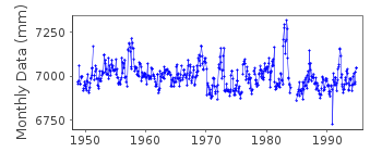
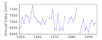
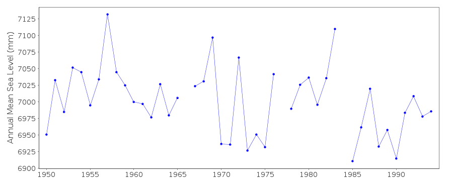
| Time span of data: | 1948 – 1994 |
| Completeness (%): | 94 |
| Date of last update: | 18 Apr 2018 |
| Green Arrow: | Current Station |
| Yellow Marker: | Neighbouring RLR Station |
| Red Marker: | Neighbouring Metric Station |
Please note: In many cases, the station position in our database is accurate to only one minute. Thus, the tide gauge may not appear to be on the coast.
Tide Gauge Data
Additional Data Sources (guide to additional data sources)
Nearby Real Time Stations from VLIZ: laliFast Delivery Data from UHSLC station 91: hourly and daily
Research Quality Data from UHSLC station 91: hourly and daily
Station Documentation
Link to RLR information.Documentation - date unknown
La Libertad II 845/012 RLR(1989) is 19.1m below BM8Documentation added 1997-11-14
Instrument type: standard mechanical tide gauge (1949-present);Leupold Stevens analog-to-digital recorder (ADR)(5/1985-present) (backup);Handar Encoder (ENC) model 436A (5/1985-present) (backup)Documentation added 2018-04-18
The UHSLC data for La Libertad 1995 onwards has now been removed from this dataset. The UHSLC data has been entered onto the database as a separate station.Data Authority
Oceanographic Institute of the NavyAv. July 25 Via Puerto Maritime
Naval Base South
Guayaquil

![]()
![]()
![]()
