Data
- Obtaining
- Supplying
- High-Frequency
- Bottom Pressure Records
- Other Long Records
- GLOSS/ODINAFRICA Calibration Data
Donate
Donate to PSMSL
Data Notes
- Individual Station Data and Plot Notes
- Referencing the Data Set
- PSMSL Help File
- 2010 Changes to the PSMSL Data Files
Extracted from Database
22 Jun 2026
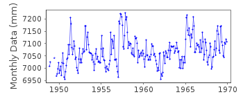
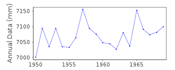
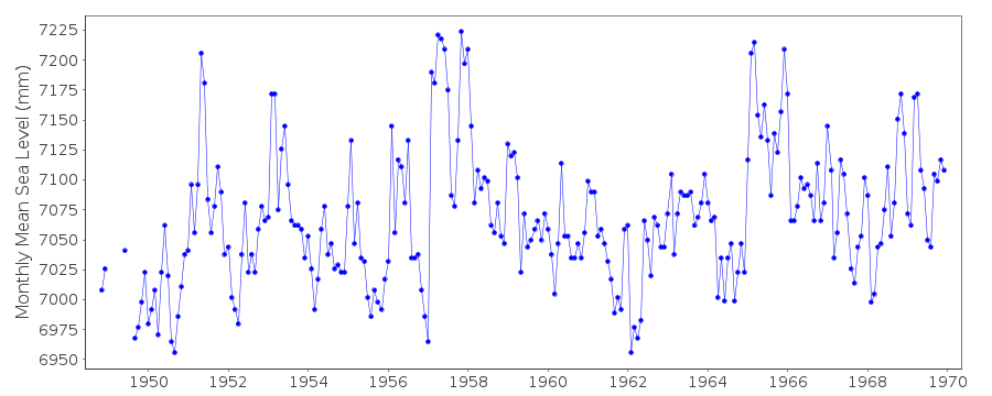
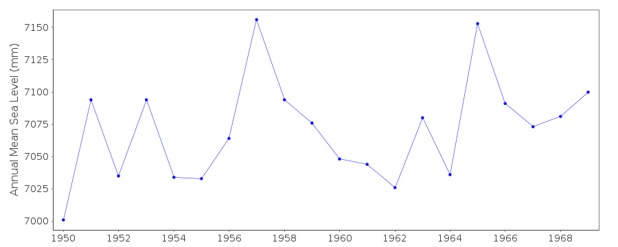
Station Information
| Station ID: | 555 |
| Latitude: | -2.2 |
| Longitude: | -80.916667 |
| GLOSS ID: | 172 |
| Coastline code: | 845 |
| Station code: | 11 |
| Country: | ECUADOR |
| Time span of data: | 1948 – 1969 |
| Completeness (%): | 94 |
| Date of last update: | 01 Jan 1980 |
| Green Arrow: | Current Station |
| Yellow Marker: | Neighbouring RLR Station |
| Red Marker: | Neighbouring Metric Station |
Please note: In many cases, the station position in our database is accurate to only one minute. Thus, the tide gauge may not appear to be on the coast.
Tide Gauge Data
Additional Data Sources (guide to additional data sources)
Nearby Real Time Stations from VLIZ: laliFast Delivery Data from UHSLC station 91: hourly and daily
Research Quality Data from UHSLC station 91: hourly and daily
Station Documentation
Link to RLR information.Documentation added 1991-06-11
La Libertad 845/011 RLR(1964) is 10.9m below BM1Documentation added 1993-07-12
La Libertad 845/011 RLR(1964) is 10.9m below BM1Documentation added 2012-01-26
This station is an historic station last data received is 1969. No furtherinformation is now available on the NOAA website. Station has been marked
'inactive'.
Data Authority
N.O.A.A. / N.O.S.N/oes33, Ssmc4, Room 6531
1305 East-West Highway
Silver Spring,
MD 20910

![]()
![]()
![]()
