Data
- Obtaining
- Supplying
- High-Frequency
- Bottom Pressure Records
- Other Long Records
- GLOSS/ODINAFRICA Calibration Data
Donate
Donate to PSMSL
Data Notes
- Individual Station Data and Plot Notes
- Referencing the Data Set
- PSMSL Help File
- 2010 Changes to the PSMSL Data Files
Extracted from Database
03 Mar 2025
Station Information
| Station ID: | 566 |
| Latitude: | 60.558333 |
| Longitude: | -145.751667 |
| Coastline code: | 821 |
| Station code: | 20 |
| Country: | UNITED STATES |
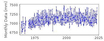
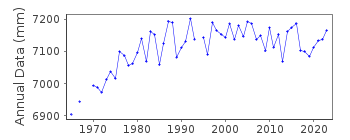
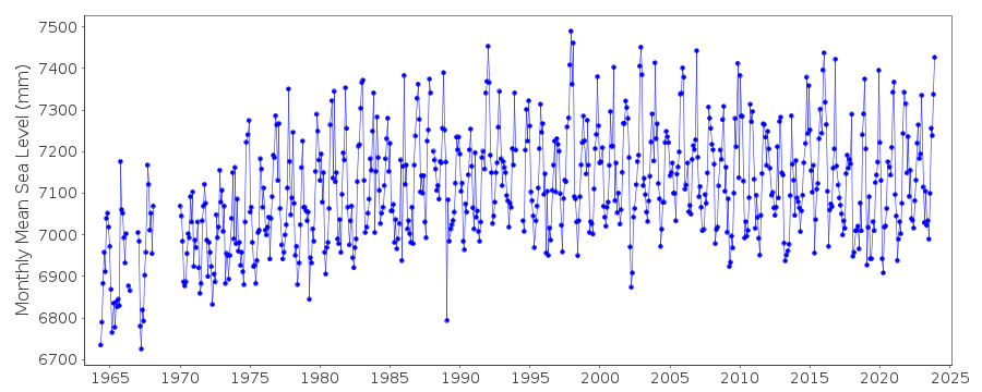
| Time span of RLR data: | 1964 – 2024 |
| RLR completeness (%): | 95 |
| Time span of metric data: | 1949 – 2024 |
| Metric completeness (%): | 80 |
| Date of last update: | 23 Jan 2025 |
| Green Arrow: | Current Station |
| Yellow Marker: | Neighbouring RLR Station |
| Red Marker: | Neighbouring Metric Station |
Please note: In many cases, the station position in our database is accurate to only one minute. Thus, the tide gauge may not appear to be on the coast.
Tide Gauge Data
Additional Data Sources (guide to additional data sources)
Nearby GNSS Stations from SONEL: EYACNearby Real Time Stations from VLIZ: cord
Research Quality Data from UHSLC station 583: hourly and daily
Station Documentation
Link to RLR information.Documentation added 1991-06-11
Cordova 821/020 RLR(1974) is 13.2m below BM11Documentation added 1992-04-02
South Alaskan Coastline Earthquake Prone - e.g. Magnitude 9.2 Earthquake of 28 March 1964 - See Savage and Plafker, JGR,96(B3), 4325-4335, 1991Documentation added 1998-12-10
Data for 1949-53 received from University of Hawaii Sea Level CenterDocumentation added 2011-11-23
Using information from the NOAA website the RLR diagram has been revised. Previous Primary benchmark 11 10.025m above gauge datum no longer appears in the NOAA reports. Secondary benchmark 4050 E 1982 7.498m above gauge datum appears both on the original RLR diagram and the NOAA report. Current Primary benchmark is 4050 Q 1998 16.455m above gauge datum.Data Authority
N.O.A.A. / N.O.S.N/oes33, Ssmc4, Room 6531
1305 East-West Highway
Silver Spring,
MD 20910

![]()
![]()
![]()
