Data
- Obtaining
- Supplying
- High-Frequency
- Bottom Pressure Records
- Other Long Records
- GLOSS/ODINAFRICA Calibration Data
Donate
Donate to PSMSL
Data Notes
- Individual Station Data and Plot Notes
- Referencing the Data Set
- PSMSL Help File
- 2010 Changes to the PSMSL Data Files
Extracted from Database
03 Mar 2025
Station Information
| Station ID: | 567 |
| Latitude: | 57.731667 |
| Longitude: | -152.511667 |
| Coastline code: | 821 |
| Station code: | 11 |
| Country: | UNITED STATES |
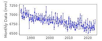
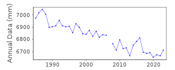
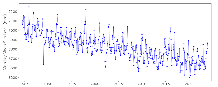
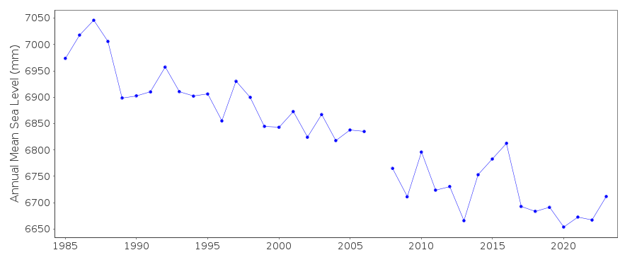
| Time span of RLR data: | 1984 – 2024 |
| RLR completeness (%): | 98 |
| Time span of metric data: | 1949 – 2024 |
| Metric completeness (%): | 73 |
| Date of last update: | 23 Jan 2025 |
| Green Arrow: | Current Station |
| Yellow Marker: | Neighbouring RLR Station |
| Red Marker: | Neighbouring Metric Station |
Please note: In many cases, the station position in our database is accurate to only one minute. Thus, the tide gauge may not appear to be on the coast.
Tide Gauge Data
Additional Data Sources (guide to additional data sources)
Nearby GNSS Stations from SONEL: KODK, AC67Nearby Real Time Stations from VLIZ: kodi
Fast Delivery Data from UHSLC station 39: hourly and daily
Research Quality Data from UHSLC station 39: hourly and daily
Station Documentation
Link to RLR information.Documentation added 1991-06-11
Womens Bay 821/011 RLR(1986) is 11.8m below BM 7292 B 1984Documentation added 1992-04-02
South Alaskan coastline is earthquake prone - e.g. Magnitude 9.2 Earthquake 28 March 1964 - See Savage and Plaker, JGR,96(B3), 4325-4335, 1991 Gauge in use at St. Pauls Harbor 1964-1984Documentation added 2011-11-24
Using information from the NOAA website the RLR diagram has been revised. Primary benchmark remains as 7292 B 1984 14.124m above gauge datum 1984 onwards. This station was previously known just as Womens Bay.Data Authority
N.O.A.A. / N.O.S.N/oes33, Ssmc4, Room 6531
1305 East-West Highway
Silver Spring,
MD 20910

![]()
![]()
![]()
