Data
- Obtaining
- Supplying
- High-Frequency
- Bottom Pressure Records
- Other Long Records
- GLOSS/ODINAFRICA Calibration Data
Donate
Donate to PSMSL
Data Notes
- Individual Station Data and Plot Notes
- Referencing the Data Set
- PSMSL Help File
- 2010 Changes to the PSMSL Data Files
Extracted from Database
03 Mar 2025
WARNING: QCFLAG EXISTS. PLEASE READ THE DOCUMENTATION.
Station Information
| Station ID: | 577 |
| Latitude: | 19.816667 |
| Longitude: | -70.7 |
| Coastline code: | 936 |
| Station code: | 21 |
| Country: | DOMINICAN REPUBLIC |
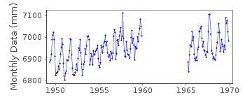
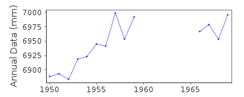
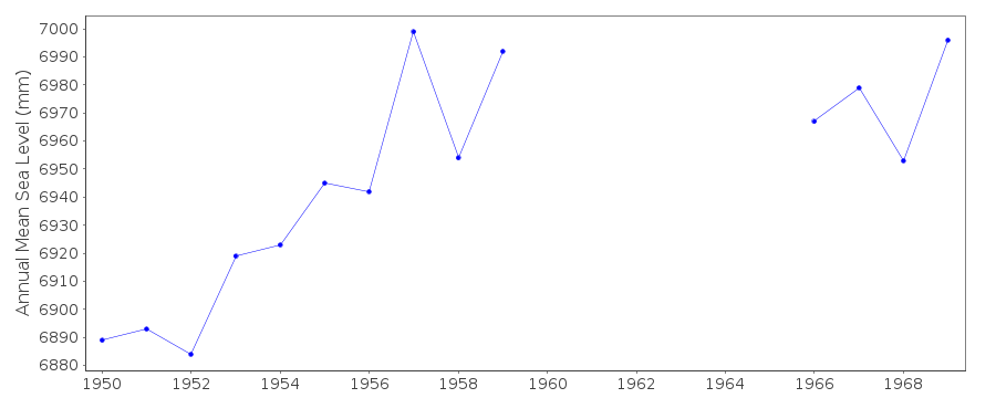
| Time span of data: | 1949 – 1969 |
| Completeness (%): | 73 |
| Date of last update: | 01 Jan 1980 |
| Green Arrow: | Current Station |
| Yellow Marker: | Neighbouring RLR Station |
| Red Marker: | Neighbouring Metric Station |
Please note: In many cases, the station position in our database is accurate to only one minute. Thus, the tide gauge may not appear to be on the coast.
Tide Gauge Data
Additional Data Sources (guide to additional data sources)
Nearby GNSS Stations from SONEL: CN07Nearby Real Time Stations from VLIZ: ptpl
Fast Delivery Data from UHSLC station 777: hourly and daily
Research Quality Data from UHSLC station 777: hourly and daily
Station Documentation
Link to RLR information.Documentation - date unknown
Puerto Plata 936/021 RLR(1959) is 9.2m below BM1Documentation added 1994-07-12
There appears to be a shift in datum following the re-instatment of the gauge for 1965 onwards.Documentation added 2012-02-09
Puerto Plata is now an Historic station. Dataset 1949-1969 with a gap 1959-1965. Puerto Plata no longer features on the NOAA website.Data Authority
N.O.A.A. / N.O.S.N/oes33, Ssmc4, Room 6531
1305 East-West Highway
Silver Spring,
MD 20910

![]()
![]()
![]()
