Data
- Obtaining
- Supplying
- High-Frequency
- Bottom Pressure Records
- Other Long Records
- GLOSS/ODINAFRICA Calibration Data
Donate
Donate to PSMSL
Data Notes
- Individual Station Data and Plot Notes
- Referencing the Data Set
- PSMSL Help File
- 2010 Changes to the PSMSL Data Files
Extracted from Database
03 Mar 2025
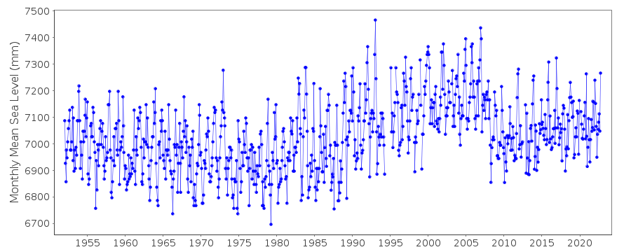
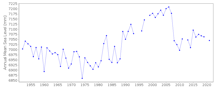
Station Information
| Station ID: | 684 |
| Latitude: | 68.966667 |
| Longitude: | 33.05 |
| GLOSS ID: | 274 |
| Coastline code: | 30 |
| Station code: | 18 |
| Country: | RUSSIAN FEDERATION |
| Time span of data: | 1952 – 2023 |
| Completeness (%): | 97 |
| Date of last update: | 19 Sep 2024 |
| Green Arrow: | Current Station |
| Yellow Marker: | Neighbouring RLR Station |
| Red Marker: | Neighbouring Metric Station |
Please note: In many cases, the station position in our database is accurate to only one minute. Thus, the tide gauge may not appear to be on the coast.
Tide Gauge Data
Station Documentation
Link to RLR information.Documentation added 1991-06-11
Murmansk 030/018 RLR(1972) is 21.8m below BMDocumentation added 2016-01-26
2014 data values for Murmansk were received in October 2015. Slightly revised data values were received 26.01.2016 these have now been entered onto the database.Data Authority
World Data CenterRussian Federal Service for Hydrometeorology
and Environmental Monitoring
6 Korolev Street, 249035 Obninsk
Kaluga Region

![]()
![]()
![]()
