Data
- Obtaining
- Supplying
- High-Frequency
- Bottom Pressure Records
- Other Long Records
- GLOSS/ODINAFRICA Calibration Data
Donate
Donate to PSMSL
Data Notes
- Individual Station Data and Plot Notes
- Referencing the Data Set
- PSMSL Help File
- 2010 Changes to the PSMSL Data Files
Extracted from Database
13 Jul 2026
Station Information
| Station ID: | 712 |
| Latitude: | 23.2 |
| Longitude: | -106.416667 |
| Coastline code: | 830 |
| Station code: | 51 |
| Country: | MEXICO |
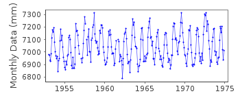
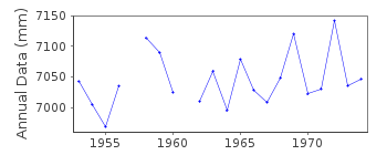
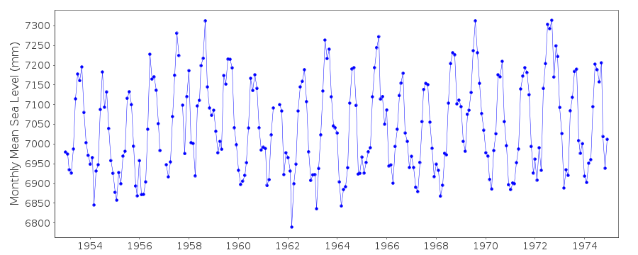
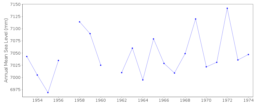
| Time span of RLR data: | 1953 – 1974 |
| RLR completeness (%): | 98 |
| Time span of metric data: | 1953 – 1990 |
| Metric completeness (%): | 61 |
| Date of last update: | 14 Feb 1996 |
| Green Arrow: | Current Station |
| Yellow Marker: | Neighbouring RLR Station |
| Red Marker: | Neighbouring Metric Station |
Please note: In many cases, the station position in our database is accurate to only one minute. Thus, the tide gauge may not appear to be on the coast.
Tide Gauge Data
Additional Data Sources (guide to additional data sources)
Research Quality Data from UHSLC station 673: hourly and dailyStation Documentation
Link to RLR information.Documentation added 1991-06-11
Mazatlan 830/051 RLR(1964) is 9.6m below BM1Documentation added 1996-02-26
Data for 1975 received from TOGA officeMazatlan is an historic station last RLR data 1974 last 'Metric' data 1990
Documentation added 1997-01-30
Large earthquake offshore of Mexico about 19 degrees North on 9 October 1995 with large tsunami generated. See article by A.E.Filonov in EOS, 78(3), 1997.Data Authority
Servicio Mareografico NacionalInstituto de Geofisica, Ciudad Universitaria
Delegacion de Coyoacan
04510 Mexico D.F.

![]()
![]()
![]()
