Data
- Obtaining
- Supplying
- High-Frequency
- Bottom Pressure Records
- Other Long Records
- GLOSS/ODINAFRICA Calibration Data
Donate
Donate to PSMSL
Data Notes
- Individual Station Data and Plot Notes
- Referencing the Data Set
- PSMSL Help File
- 2010 Changes to the PSMSL Data Files
Extracted from Database
03 Mar 2025
Station Information
| Station ID: | 723 |
| Latitude: | 38.866667 |
| Longitude: | 121.683333 |
| GLOSS ID: | 79 |
| Coastline code: | 610 |
| Station code: | 44 |
| Country: | CHINA |
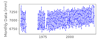
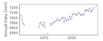
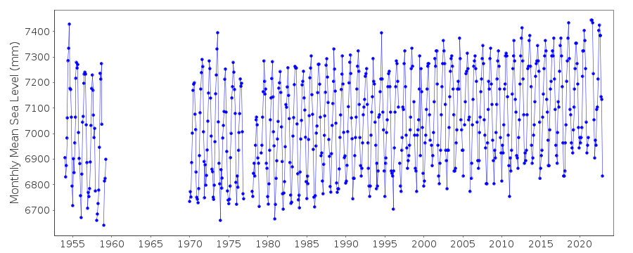
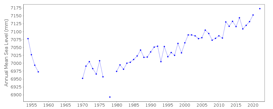
| Time span of RLR data: | 1954 – 2022 |
| RLR completeness (%): | 81 |
| Time span of metric data: | 1954 – 2022 |
| Metric completeness (%): | 83 |
| Date of last update: | 28 Mar 2023 |
| Green Arrow: | Current Station |
| Yellow Marker: | Neighbouring RLR Station |
| Red Marker: | Neighbouring Metric Station |
Please note: In many cases, the station position in our database is accurate to only one minute. Thus, the tide gauge may not appear to be on the coast.
Tide Gauge Data
Additional Data Sources (guide to additional data sources)
Research Quality Data from UHSLC station 630: hourly and dailyResearch Quality Data from UHSLC station 631: hourly and daily
Station Documentation
Link to RLR information.Documentation added 1993-09-16
Tide gauge moved and new well in 1980Documentation added 1993-10-19
Dalian 610/044 RLR(1990) is 10.4m below BMDocumentation added 1994-05-23
1954-59, 1970-74 data received from TOGA officeDocumentation added 2002-04-03
Dalian data 1977-9 clearly to different datum, and therefore removed from RLR.Documentation added 2003-02-10
Data for 1977-1979 were replaced by monthly mean from University of Hawaii (10.02.03)Documentation added 2003-02-10
Data for 1993-1999 are from University of Hawaii.Data Authority
National Marine Data and Information Service (NMDIS)No. 93 Liuwei Road
Tianjin 300171

![]()
![]()
![]()
