Data
- Obtaining
- Supplying
- High-Frequency
- Bottom Pressure Records
- Other Long Records
- GLOSS/ODINAFRICA Calibration Data
Donate
Donate to PSMSL
Data Notes
- Individual Station Data and Plot Notes
- Referencing the Data Set
- PSMSL Help File
- 2010 Changes to the PSMSL Data Files
Extracted from Database
03 Mar 2025
Station Information
| Station ID: | 74 |
| Latitude: | 57.683333 |
| Longitude: | 11.9 |
| Coastline code: | 50 |
| Station code: | 31 |
| Country: | SWEDEN |
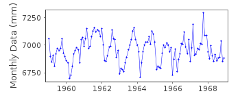
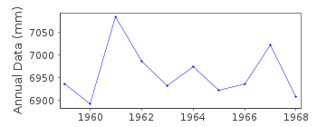
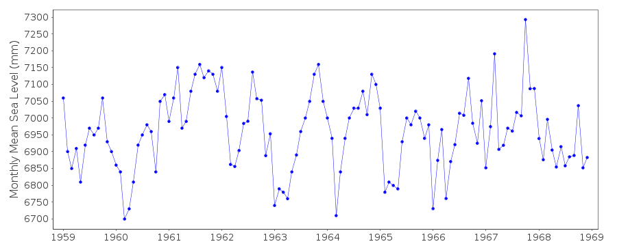
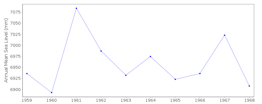
| Time span of data: | 1959 – 1968 |
| Completeness (%): | 100 |
| Date of last update: | 01 Mar 2012 |
| Green Arrow: | Current Station |
| Yellow Marker: | Neighbouring RLR Station |
| Red Marker: | Neighbouring Metric Station |
Please note: In many cases, the station position in our database is accurate to only one minute. Thus, the tide gauge may not appear to be on the coast.
Tide Gauge Data
Additional Data Sources (guide to additional data sources)
Nearby GNSS Stations from SONEL: 0KRO, 1BAG, 0BRU, 0BIS, 0FRLNearby Real Time Stations from VLIZ: goti, gokr, goer, gohi, tang
Fast Delivery Data from UHSLC station 819: hourly and daily
Research Quality Data from UHSLC station 819: hourly and daily
Station Documentation
Link to RLR information.Documentation - date unknown
Hourly data values commence 01/01/1959Documentation added 1991-06-11
Goteborg-Klippan 050/031 RLR(1964) is 10.4m below BM Fix 2013Documentation added 1993-07-12
Goteborg-Klippan 050/031 RLR(1964) is 10.4m below BM Fix 2013Documentation added 1993-07-29
Value for August 1953 looks low compared to neighbours values - checkedcorrect as received from authority.
Documentation added 2012-03-21
Previously the datasets for both Gotegorg-Ringon and Goteborg-Klippan weretreated as one series. However, the SMHI treat them as two separate stations.
The data was separated to mirror the SMHI website. The benchmark name was
revised from BM No. Fix 2013 to BM 'A' following comfirmation from the SMHI.
Data Authority
Swedish Met. and Hyd. InstituteBox 923
S601 76 Norrkoping

![]()
![]()
![]()
