Data
- Obtaining
- Supplying
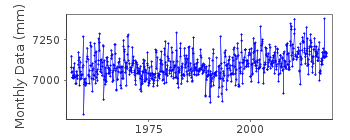
- High-Frequency
- Bottom Pressure Records
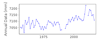
- Other Long Records
- GLOSS/ODINAFRICA Calibration Data
Donate
Donate to PSMSL
Data Notes
- Individual Station Data and Plot Notes
- Referencing the Data Set
- PSMSL Help File
- 2010 Changes to the PSMSL Data Files
Extracted from Database
03 Mar 2025
Station Information
| Station ID: | 760 |
| Latitude: | 42.6583 |
| Longitude: | 18.0633 |
| Coastline code: | 280 |
| Station code: | 81 |
| Country: | CROATIA |
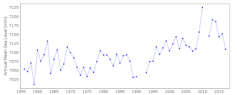
| Time span of RLR data: | 1956 – 2018 |
| RLR completeness (%): | 99 |
| Time span of metric data: | 1955 – 2018 |
| Metric completeness (%): | 98 |
| Date of last update: | 11 Jul 2019 |
| Green Arrow: | Current Station |
| Yellow Marker: | Neighbouring RLR Station |
| Red Marker: | Neighbouring Metric Station |
Please note: In many cases, the station position in our database is accurate to only one minute. Thus, the tide gauge may not appear to be on the coast.
Tide Gauge Data
Additional Data Sources (guide to additional data sources)
Nearby GNSS Stations from SONEL: DUBR, DUB2Station Documentation
Link to RLR information.Documentation added 1991-06-11
Dubrovnik 280/081 RLR(1964) is 11.3m below BMDocumentation added 1992-03-04
Prior to 1990 data from Hidrografski Institut, SplitDocumentation added 1996-01-12
Tide gauge of the State Hydrographic Institute at SplitDocumentation added 1996-01-12
Gauge=A. Ott, KemptenDocumentation added 2011-01-20
The tide gauge at Dubrovnik has been operational since 1956.Following receipt of a station information sheet: Primary benchmark is R1 5.333. above TGZ. Secondary benchmark is A 496 4.789 above TGZ. RLR factor is 5.967m.Documentation added 2019-07-16
When plotted there is evidence of a surge in March 2018.Data Authority
Hidrografski Institut of Rep. of CroatiaZrinsko-Frankopanska 161
21000 Split

![]()
![]()
![]()
