Data
- Obtaining
- Supplying
- High-Frequency
- Bottom Pressure Records
- Other Long Records
- GLOSS/ODINAFRICA Calibration Data
Donate
Donate to PSMSL
Data Notes
- Individual Station Data and Plot Notes
- Referencing the Data Set
- PSMSL Help File
- 2010 Changes to the PSMSL Data Files
Extracted from Database
03 Mar 2025
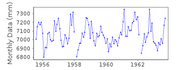
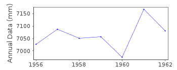
Station Information
| Station ID: | 781 |
| Latitude: | 65.85 |
| Longitude: | 13.2 |
| Coastline code: | 40 |
| Station code: | 121 |
| Country: | NORWAY |
| Time span of data: | 1955 – 1963 |
| Completeness (%): | 90 |
| Date of last update: | 01 Jan 1980 |
| Green Arrow: | Current Station |
| Yellow Marker: | Neighbouring RLR Station |
| Red Marker: | Neighbouring Metric Station |
Please note: In many cases, the station position in our database is accurate to only one minute. Thus, the tide gauge may not appear to be on the coast.
Tide Gauge Data
Station Documentation
Link to RLR information.Documentation added 1991-06-11
Mosjoen 040/121 RLR(1963) is 10.2m below BM J17 N6Datum for data 1955-1958 is the same as the benchmark line. This is an historic station last data 1963
Data Authority
Statens KartverkGeodesidivisjonen
3500 Honefoss

![]()
![]()
![]()
