Data
- Obtaining
- Supplying
- High-Frequency
- Bottom Pressure Records
- Other Long Records
- GLOSS/ODINAFRICA Calibration Data
Donate
Donate to PSMSL
Data Notes
- Individual Station Data and Plot Notes
- Referencing the Data Set
- PSMSL Help File
- 2010 Changes to the PSMSL Data Files
Extracted from Database
13 Jul 2026
Station Information
| Station ID: | 795 |
| Latitude: | 31.85 |
| Longitude: | -116.633333 |
| Coastline code: | 830 |
| Station code: | 1 |
| Country: | MEXICO |
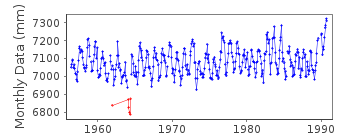
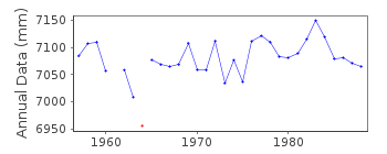
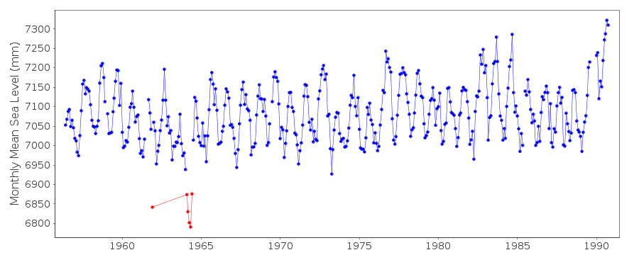
| Time span of data: | 1956 – 1990 |
| Completeness (%): | 96 |
| Date of last update: | 12 Jan 2012 |
| Green Arrow: | Current Station |
| Yellow Marker: | Neighbouring RLR Station |
| Red Marker: | Neighbouring Metric Station |
Please note: In many cases, the station position in our database is accurate to only one minute. Thus, the tide gauge may not appear to be on the coast.
Tide Gauge Data
Additional Data Sources (guide to additional data sources)
Nearby GNSS Stations from SONEL: CICE, IMIE, CIC1Fast Delivery Data from UHSLC station 317: hourly and daily
Research Quality Data from UHSLC station 317: hourly and daily
Station Documentation
Link to RLR information.Documentation added 1991-06-11
Ensenada 830/001 RLR(1964) is 9.8m below BM1Documentation added 1993-07-29
Anomalously low values December 1961 and July 1963 - June 1964 - correct as received from authority.Documentation added 1997-01-30
Large earthquake offshore of Mexico about 19 degrees North on 9 October 1995 with large tsunami generated. See article by A.E.Filonov in EOS, 78(3), 1997.Documentation added 2012-01-12
When the above comment was entered the only way to flag any particular point was to flag the whole year. This no longer applies with the new database. The flagging has been edited so that December 1961 is the only point flagged. Data for 1963-64 has also been reviewed and datapoints now flagged are just February-June 1964. Ensenada is an historic station last data 1990Data Authority
Servicio Mareografico NacionalInstituto de Geofisica, Ciudad Universitaria
Delegacion de Coyoacan
04510 Mexico D.F.

![]()
![]()
![]()
