Data
- Obtaining
- Supplying
- High-Frequency
- Bottom Pressure Records
- Other Long Records
- GLOSS/ODINAFRICA Calibration Data
Donate
Donate to PSMSL
Data Notes
- Individual Station Data and Plot Notes
- Referencing the Data Set
- PSMSL Help File
- 2010 Changes to the PSMSL Data Files
Extracted from Database
03 Mar 2025
Station Information
| Station ID: | 813 |
| Latitude: | 41.781667 |
| Longitude: | 140.724722 |
| GLOSS ID: | 88 |
| Coastline code: | 641 |
| Station code: | 31 |
| Country: | JAPAN |
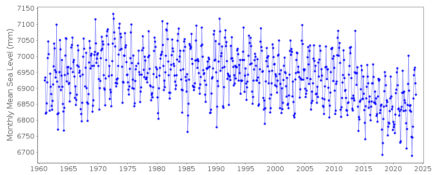
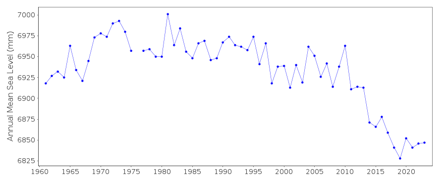
| Time span of RLR data: | 1961 – 2023 |
| RLR completeness (%): | 99 |
| Time span of metric data: | 1957 – 2023 |
| Metric completeness (%): | 99 |
| Link to ellipsoid: | Available |
| Date of last update: | 04 Mar 2024 |
| Green Arrow: | Current Station |
| Yellow Marker: | Neighbouring RLR Station |
| Red Marker: | Neighbouring Metric Station |
Please note: In many cases, the station position in our database is accurate to only one minute. Thus, the tide gauge may not appear to be on the coast.
Tide Gauge Data
Additional Data Sources (guide to additional data sources)
Nearby GNSS Stations from SONEL: P204Nearby Real Time Stations from VLIZ: hako
Fast Delivery Data from UHSLC station 364: hourly and daily
Research Quality Data from UHSLC station 364: hourly and daily
Station Documentation
Link to RLR information.Documentation added 1991-06-11
Hakodate I 641/031 RLR(1972) is 9.0m below Attached BMDocumentation added 1995-08-29
A destructive earthquake and tsunami occurred in the Kuril Islands on 4 October 1994 - see Earth System Monitor, 5(4), June 1995.Documentation added 2003-11-20
Datum 1998 is 1.434m below Tokyo Peil.Documentation added 2012-02-21
A massive earthquake magnitude 9.0 occurred at 14.46 JST (05.46 UTC) on Friday 11th March 2011 with the epicentre approx. 70 km east of the Oshika Peninsula of Tohoku. It was the most powerful known earthquake to hit Japan triggering a tsunami with waves up to 40.5m and travelling up to 10km inland.Documentation added 2014-03-13
The GPS benchmark information has been downloaded from SONEL website. GPS benchmark P204 is 12.141m above RLR.Data Authority
Japan Meteorological Agency3-6-9 Toranomon, Minato City
Tokyo

![]()
![]()
![]()
