Data
- Obtaining
- Supplying
- High-Frequency
- Bottom Pressure Records
- Other Long Records
- GLOSS/ODINAFRICA Calibration Data
Donate
Donate to PSMSL
Data Notes
- Individual Station Data and Plot Notes
- Referencing the Data Set
- PSMSL Help File
- 2010 Changes to the PSMSL Data Files
Extracted from Database
13 Jul 2026
Station Information
| Station ID: | 822 |
| Latitude: | -27.366667 |
| Longitude: | 153.166667 |
| GLOSS ID: | 58 |
| Coastline code: | 680 |
| Station code: | 78 |
| Country: | AUSTRALIA |
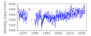
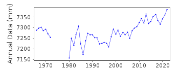
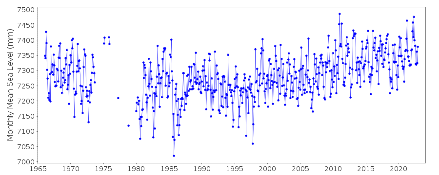
| Time span of RLR data: | 1966 – 2022 |
| RLR completeness (%): | 89 |
| Time span of metric data: | 1957 – 2022 |
| Metric completeness (%): | 81 |
| Date of last update: | 27 Feb 2023 |
| Green Arrow: | Current Station |
| Yellow Marker: | Neighbouring RLR Station |
| Red Marker: | Neighbouring Metric Station |
Please note: In many cases, the station position in our database is accurate to only one minute. Thus, the tide gauge may not appear to be on the coast.
Tide Gauge Data
Additional Data Sources (guide to additional data sources)
Nearby GNSS Stations from SONEL: WOOL, CLEVFast Delivery Data from UHSLC station 331: hourly and daily
Research Quality Data from UHSLC station 331: hourly and daily
Station Documentation
Link to RLR information.Documentation added 1995-05-02
Station density along some sections of the Australian coast has meant that station codes 601 onwards have been re-ordered compared to those in earlier versions of the PSMSL data set. DATA Data for 1961-1964 supplied by Queensland D.O.T. The gauge was re-sited in 1982Documentation added 1996-05-17
Data for 1957-58,1966-84 revised with new set received from the National Tidal Centre, Bureau of Meteorology, South AustraliaDocumentation added 1998-01-23
Gauge located on a navigation beacon at the mouth of the Brisbane River gauge type: currently pneumatic bubbler 1964-66 float/stilling well on Bishop Island 1966-80 float/stilling well at West Inner Bar 1980-1982 pressure diaphragm gauge at Bishop IslandDocumentation added 2002-05-28
Brisbane 680/078 RLR(2000) is 9.102m below BM PSM 21764Documentation added 2013-01-07
From documentation downloaded from NTC primary benchmark remains PSM 21764 3.102m above datumData Authority
National Tidal CentreBureau of Meteorology
PO Box 421
Kent Town 5071
South Australia
Documentation added 2010-08-12
Formerly known as the National Tidal Facility

![]()
![]()
![]()
