Data
- Obtaining
- Supplying
- High-Frequency
- Bottom Pressure Records
- Other Long Records
- GLOSS/ODINAFRICA Calibration Data
Donate
Donate to PSMSL
Data Notes
- Individual Station Data and Plot Notes
- Referencing the Data Set
- PSMSL Help File
- 2010 Changes to the PSMSL Data Files
Extracted from Database
03 Mar 2025
WARNING: QCFLAG EXISTS. PLEASE READ THE DOCUMENTATION.
Station Information
| Station ID: | 827 |
| Latitude: | 59.55 |
| Longitude: | 150.716667 |
| GLOSS ID: | 92 |
| Coastline code: | 630 |
| Station code: | 11 |
| Country: | RUSSIAN FEDERATION |
| Time span of data: | 1957 – 2023 |
| Completeness (%): | 96 |
| Date of last update: | 19 Sep 2024 |
| Green Arrow: | Current Station |
| Yellow Marker: | Neighbouring RLR Station |
| Red Marker: | Neighbouring Metric Station |
Please note: In many cases, the station position in our database is accurate to only one minute. Thus, the tide gauge may not appear to be on the coast.
Tide Gauge Data
Station Documentation
Link to RLR information.Documentation added 1993-03-17
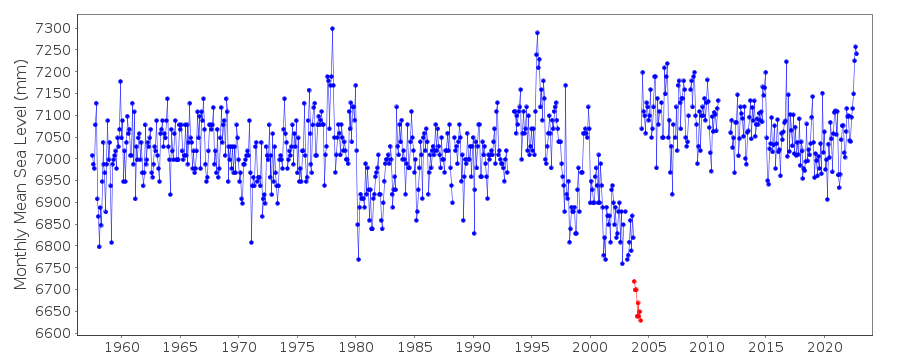
Several datum shifts suggested in RLR record e.g. about March 1980.Documentation added 1993-07-12
Nagaeva Bay 630/011 RLR(1964) is 11.5m below BM No1Documentation added 1995-08-29
A destructive earthquake and tsunami occurred in the Kuril Islands on 4 October 1994 - see Earth System Monitor, 5(4), June 1995.Documentation added 1996-02-19
Data Jan-Jun 1993 omitted because of gauge failureDocumentation added 2008-07-08
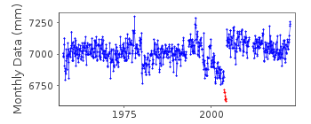
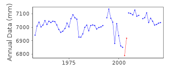
Following enquiries from PSMSL Dr. Oleinikoff of the Russian NODC confirmed that the Mean Sea Level data for the period October 2003 to May 2004 is defective. Relevent data has been flagged.Documentation added 2013-01-28
There is no data available for 2011 due to a gauge malfunction.Documentation added 2016-01-26
Data for Nagayevo for 2014 were received in October 2015. Slightly revised data values were received 26-01-2016 these have been entered onto the database.Data Authority
World Data CenterRussian Federal Service for Hydrometeorology
and Environmental Monitoring
6 Korolev Street, 249035 Obninsk
Kaluga Region

![]()
![]()
![]()
