Data
- Obtaining
- Supplying
- High-Frequency
- Bottom Pressure Records
- Other Long Records
- GLOSS/ODINAFRICA Calibration Data
Donate
Donate to PSMSL
Data Notes
- Individual Station Data and Plot Notes
- Referencing the Data Set
- PSMSL Help File
- 2010 Changes to the PSMSL Data Files
Extracted from Database
03 Mar 2025
Station Information
| Station ID: | 830 |
| Latitude: | 60.154028 |
| Longitude: | -1.140306 |
| GLOSS ID: | 236 |
| Coastline code: | 170 |
| Station code: | 1 |
| Country: | UNITED KINGDOM |
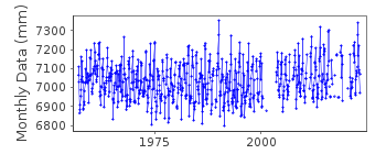
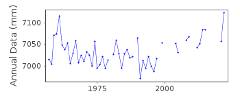
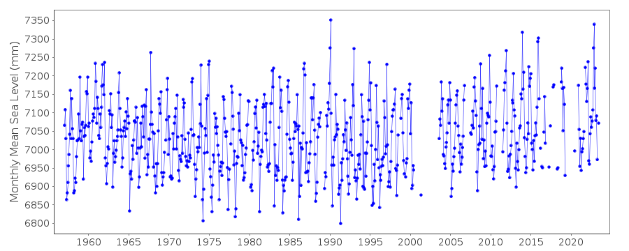
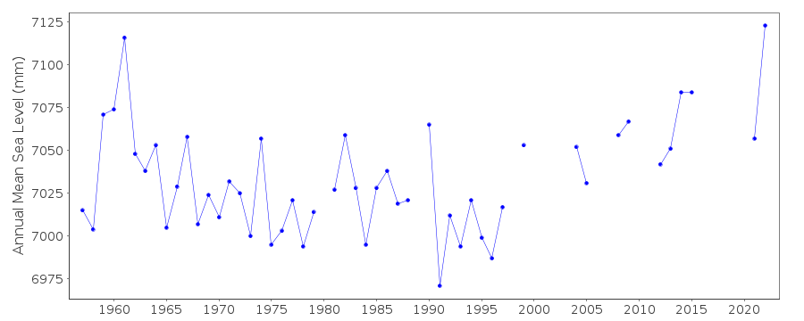
| Time span of data: | 1957 – 2024 |
| Completeness (%): | 86 |
| Link to ellipsoid: | Available |
| Date of last update: | 18 Feb 2025 |
| Green Arrow: | Current Station |
| Yellow Marker: | Neighbouring RLR Station |
| Red Marker: | Neighbouring Metric Station |
Please note: In many cases, the station position in our database is accurate to only one minute. Thus, the tide gauge may not appear to be on the coast.
Tide Gauge Data
Additional Data Sources (guide to additional data sources)
Nearby GNSS Stations from SONEL: LERI, LWTGNearby Real Time Stations from VLIZ: lerw2
Fast Delivery Data from UHSLC station 293: hourly and daily
Research Quality Data from UHSLC station 293: hourly and daily
Station Documentation
Link to RLR information.Documentation added 1991-06-11
Lerwick 170/001 RLR(1987) is 10.3m below TGBM HU4783 4129Documentation added 1994-09-16
A Munro gauge is known to have been installed in December 1956, although a Lea system must have been operating prior to that. Another Lea replaced the Munro in November 1963. From May 1989 the gauge has been an "A Class" bubbler.Documentation added 2001-01-02
Recent work on vertical land movements in the UK can be found from the University of Nottingham web site: http://ukcogr.iessg.nottingham.ac.uk/~eosi/Documentation added 2012-05-22
When updating the RLR diagram to include Ordnance Datum Newlyn (ODN) it was noted that this is the same value as used for data for the period 1965-1979 and also agrees with the formally used Ordnance Datum Liverpool (ODL).Documentation added 2015-05-18
TGI were at site 31.03.14 to carry out general maintenance and to change the compressor.Data Authority
Environment AgencyHorizon House
Deanery Road
BS1 5AH
Bristol

![]()
![]()
![]()
