Data
- Obtaining
- Supplying
- High-Frequency
- Bottom Pressure Records
- Other Long Records
- GLOSS/ODINAFRICA Calibration Data
Donate
Donate to PSMSL
Data Notes
- Individual Station Data and Plot Notes
- Referencing the Data Set
- PSMSL Help File
- 2010 Changes to the PSMSL Data Files
Extracted from Database
03 Mar 2025
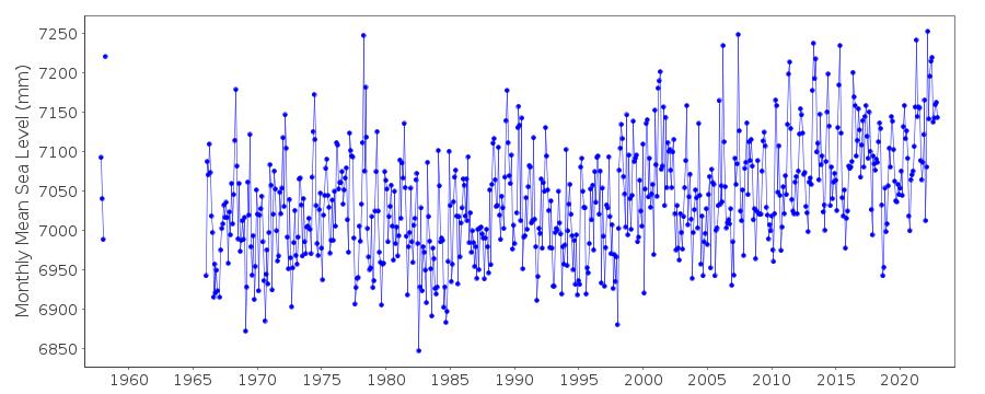
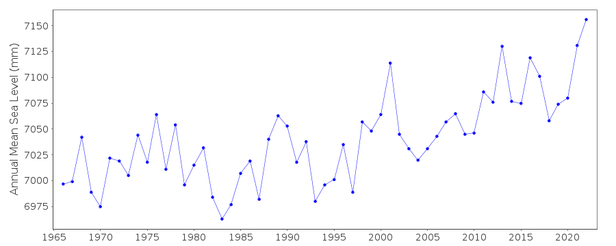
Station Information
| Station ID: | 837 |
| Latitude: | -32.924 |
| Longitude: | 151.788583 |
| Coastline code: | 680 |
| Station code: | 135 |
| Country: | AUSTRALIA |
| Time span of data: | 1957 – 2022 |
| Completeness (%): | 87 |
| Date of last update: | 01 Feb 2024 |
| Green Arrow: | Current Station |
| Yellow Marker: | Neighbouring RLR Station |
| Red Marker: | Neighbouring Metric Station |
Please note: In many cases, the station position in our database is accurate to only one minute. Thus, the tide gauge may not appear to be on the coast.
Tide Gauge Data
Additional Data Sources (guide to additional data sources)
Nearby GNSS Stations from SONEL: NEWE, NWCSStation Documentation
Link to RLR information.Documentation added 1995-05-02
Station density along some sections of the Australian coast has meant that station codes 601 onwards have been re-ordered compared to those in earlier versions of the PSMSL data set.Documentation added 2010-08-26
Supplying authority have confirmed that tide gauge zero is 1.009 m below AHD (Australian Height Datum) Tide gauge benchmark PM 60000 is 4.267 m above tide gauge zero RLR (2009) is defined as 10.3 m below PM 60000Documentation added 2010-11-04
It has been confirmed that the present dataset for Newcastle is a compendium of station 267 to the end of the record (December 1988) and then station 837 from January 1989 to present. Apparently both gauges were run in parallel for a number of years until station 837 was synched with the monthly records of station 267 when 837 became the primary gauge. See Phil Watson's letter of 25.10.10. The numbers have also been checked and the situation verified.Data Authority
National Tidal CentreBureau of Meteorology
PO Box 421
Kent Town 5071
South Australia
Documentation added 2010-08-12
Formerly known as the National Tidal Facility

![]()
![]()
![]()
