Data
- Obtaining
- Supplying
- High-Frequency
- Bottom Pressure Records
- Other Long Records
- GLOSS/ODINAFRICA Calibration Data
Donate
Donate to PSMSL
Data Notes
- Individual Station Data and Plot Notes
- Referencing the Data Set
- PSMSL Help File
- 2010 Changes to the PSMSL Data Files
Extracted from Database
22 Jun 2026
Station Information
| Station ID: | 844 |
| Latitude: | 9.4 |
| Longitude: | -84.166667 |
| GLOSS ID: | 167 |
| Coastline code: | 836 |
| Station code: | 11 |
| Country: | COSTA RICA |
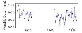
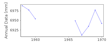
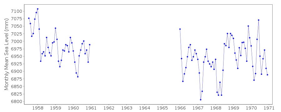
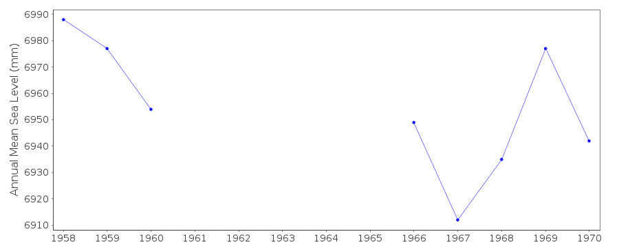
| Time span of RLR data: | 1957 – 1970 |
| RLR completeness (%): | 61 |
| Time span of metric data: | 1957 – 1994 |
| Metric completeness (%): | 98 |
| Date of last update: | 14 Oct 2013 |
| Green Arrow: | Current Station |
| Yellow Marker: | Neighbouring RLR Station |
| Red Marker: | Neighbouring Metric Station |
Please note: In many cases, the station position in our database is accurate to only one minute. Thus, the tide gauge may not appear to be on the coast.
Tide Gauge Data
Additional Data Sources (guide to additional data sources)
Nearby Real Time Stations from VLIZ: quepoFast Delivery Data from UHSLC station 87: hourly and daily
Research Quality Data from UHSLC station 87: hourly and daily
Station Documentation
Link to RLR information.Documentation - date unknown
Data 1957-1968 supplied by N.O.A.A.Documentation added 1991-06-11
Quepos 836/011 RLR(1964) is 11.9m below BM1QDocumentation added 1992-09-14
RLR redefined with new information 14/9/92Documentation added 1992-11-06
1988-89 abnormally low effect of La NinaDocumentation added 1993-07-12
Quepos 836/011 RLR(1987) is 11.9m below BM ADocumentation added 1994-05-23
1990-92 data received from TOGA officeDocumentation added 1994-12-12
1993 data received from TOGA officeDocumentation added 1995-03-09
Data 1971-1993 received from TOGA office replaced previous FISCHER & PORTER ADR in use since 1992Documentation added 1997-01-29
1994 data received from TOGA officeData Authority
University of Hawaii Sea Level CenterDepartment of Oceanography Division of Natural Sciences
1000 Pope Road
Honolulu
Hawaii 96822

![]()
![]()
![]()
