Data
- Obtaining
- Supplying
- High-Frequency
- Bottom Pressure Records
- Other Long Records
- GLOSS/ODINAFRICA Calibration Data
Donate
Donate to PSMSL
Data Notes
- Individual Station Data and Plot Notes
- Referencing the Data Set
- PSMSL Help File
- 2010 Changes to the PSMSL Data Files
Extracted from Database
03 Mar 2025
Station Information
| Station ID: | 852 |
| Latitude: | -22.3 |
| Longitude: | 166.433333 |
| GLOSS ID: | 123 |
| Coastline code: | 740 |
| Station code: | 1 |
| Country: | NEW CALEDONIA |
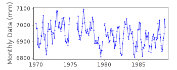
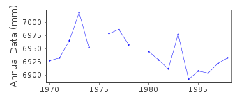
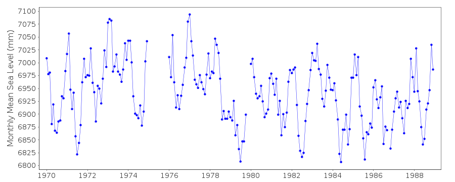
| Time span of RLR data: | 1970 – 1988 |
| RLR completeness (%): | 93 |
| Time span of metric data: | 1957 – 1988 |
| Metric completeness (%): | 83 |
| Link to ellipsoid: | Available |
| Date of last update: | 13 Sep 1991 |
| Green Arrow: | Current Station |
| Yellow Marker: | Neighbouring RLR Station |
| Red Marker: | Neighbouring Metric Station |
Please note: In many cases, the station position in our database is accurate to only one minute. Thus, the tide gauge may not appear to be on the coast.
Tide Gauge Data
Additional Data Sources (guide to additional data sources)
Nearby GNSS Stations from SONEL: NOUM, NRMG, NBTG, NRMDNearby Real Time Stations from VLIZ: numbo, numb2
Fast Delivery Data from UHSLC station 19: hourly and daily
Research Quality Data from UHSLC station 19: hourly and daily
Station Documentation
Link to RLR information.Documentation added 1991-06-11
Noumea 740/001 RLR(1978) is 10.4m below Repere I1Documentation added 2012-03-27
Full position name for this tide gauge is Noumea-Chaleix. No further data is available from this station as it has been replaced by tide gauge Noumea-Numbo. The Chart Datum for the gauges differ so they will remain as two separate series.Data Authority
SHOM13 rue de Chatelier
29200 BREST

![]()
![]()
![]()
