Data
- Obtaining
- Supplying
- High-Frequency
- Bottom Pressure Records
- Other Long Records
- GLOSS/ODINAFRICA Calibration Data
Donate
Donate to PSMSL
Data Notes
- Individual Station Data and Plot Notes
- Referencing the Data Set
- PSMSL Help File
- 2010 Changes to the PSMSL Data Files
Extracted from Database
03 Mar 2025
Station Information
| Station ID: | 87 |
| Latitude: | 45.416667 |
| Longitude: | 12.35 |
| Coastline code: | 270 |
| Station code: | 41 |
| Country: | ITALY |
| Time span of data: | 1889 – 1913 |
| Completeness (%): | 96 |
| Date of last update: | 01 Jan 1980 |
| Green Arrow: | Current Station |
| Yellow Marker: | Neighbouring RLR Station |
| Red Marker: | Neighbouring Metric Station |
Please note: In many cases, the station position in our database is accurate to only one minute. Thus, the tide gauge may not appear to be on the coast.
Tide Gauge Data
Additional Data Sources (guide to additional data sources)
Nearby GNSS Stations from SONEL: VENE, VEN1, VEAR, VENI, PSALNearby Real Time Stations from VLIZ: VE19
Station Documentation
Link to RLR information.Documentation added 1991-06-11
Venezia(Arsenale) 270/041 RLR(1913) is 10.5m below BMDocumentation added 1993-07-12
Venezia(Arsenale) 270/041 RLR(1913) is 10.5m below BMDocumentation added 1994-07-14
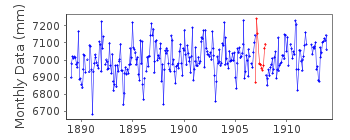
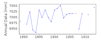
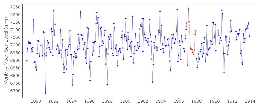
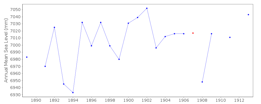
Anomalously large values for February-March 1907 compared to Trieste.Documentation added 1994-07-14
For a discussion of submergence near to Venicesee Emery and Aubrey (Sea Levels, Land Levels and
Tide Gauges), 1991, Springer-Verlag, page 34.
Venezia (Arsenale is an historic station. Last data 1913
Data Authority
Istituto Idrografico della MarinaPasso Osservatorio 4
16134 Genova

![]()
![]()
![]()
