Data
- Obtaining
- Supplying
- High-Frequency
- Bottom Pressure Records
- Other Long Records
- GLOSS/ODINAFRICA Calibration Data
Donate
Donate to PSMSL
Data Notes
- Individual Station Data and Plot Notes
- Referencing the Data Set
- PSMSL Help File
- 2010 Changes to the PSMSL Data Files
Extracted from Database
11 May 2026
Station Information
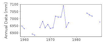
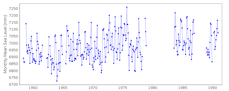
| Station ID: | 919 |
| Latitude: | 26.068333 |
| Longitude: | -97.151667 |
| Coastline code: | 940 |
| Station code: | 3 |
| Country: | UNITED STATES |
| Time span of data: | 1958 – 1990 |
| Completeness (%): | 72 |
| Date of last update: | 16 Jul 1993 |
| Green Arrow: | Current Station |
| Yellow Marker: | Neighbouring RLR Station |
| Red Marker: | Neighbouring Metric Station |
Please note: In many cases, the station position in our database is accurate to only one minute. Thus, the tide gauge may not appear to be on the coast.
Tide Gauge Data

Additional Data Sources (guide to additional data sources)
Research Quality Data from UHSLC station 772: hourly and dailyStation Documentation
Link to RLR information.Documentation added 1991-06-11
Padre Island 940/003 RLR(1973) is 8.4m below BM2USEDocumentation added 1993-07-29
Many stations on the Gulf coast have large values for September 1961.Documentation added 2012-02-09
Padre Island is an Historic station. Last data received was that for 1990. Although it is still included in the NOAA listing of Historic Data the is no longer any benchmark or datum information available.Data Authority
N.O.A.A. / N.O.S.N/oes33, Ssmc4, Room 6531
1305 East-West Highway
Silver Spring,
MD 20910

![]()
![]()
![]()
