Geophysical Signals in Tide Gauge Data
Tide gauges are often used to study long-term variations in currents and the volume of water in the oceans, which can be affected by changes in temperature, salinity, and the balance of fresh water flux and evaporation. However, other geophysical signals are also present in tide gauge data (a limited set of examples):
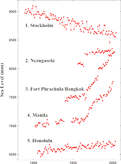
- Glacial Isostatic Adjustment (GIA; sometimes called Post Glacial Rebound or PGR): Site near Stockholm shows large negative trend due to crustal uplift. Further information and predictions.
- Earthquakes: The sea level record from Nezugaseki, Japan, demonstrates an abrupt jump following the 1964 earthquake.
- Ground water extraction: Due to increased groundwater extraction since about 1960, the crust near Fort Phrachula Bangkok, Thailand, has subsided causing a sea level rise.
- Sedimentation: Deposits from river discharge and reclamation work in Manila load the crust and cause a sea level rise.
- A 'typical' signal in Hawaii that is in the 'far field' of GIA and without strong tectonic signals evident on timescales comparable to the length of the tide gauge record. (See note at end.)
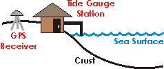
This simplified cartoon conceptualises how a tide gauge measures changes in sea level. The station itself is based upon land (the Earth's crust) and measures changes in the sea surface relative to this position. Thus, if either the crust subsides or the sea surface uplifts, the tide gauge will measure a sea level rise. Therefore, these two effects cannot be separated with tide gauge data alone. Using GPS receivers near tide gauges to measure land motion provides additional information to separate these two effects. Further information on GPS at tide gauges.
Finally, changes in atmospheric pressure will cause sea level to change. Frequently, these effects are removed using atmospheric pressure data sets.
Note: The Honolulu record is shown above for comparison only. It should not be interpreted as suggesting that the Hawaiian islands to be completely 'stable', as is obvious from their volcanic history. Similar comments would apply to other far field sites with long records but for different geological reasons depending on the location. In brief, we do not believe any land to be completely 'stable', which is the main motivation for interest in measuring vertical land movements.

![]()
![]()
![]()
