Products
- Google Earth Visualisation
- PSMSL Data Coverage
- GLOSS Station Handbook
- Mean Sea Level Anomalies
- Derived Trends
- Sea Level Reconstructions
- Commentaries
- Author Archive
- GLOSS-Related Information
Donate
Donate to PSMSL
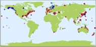
Explore the Dataset
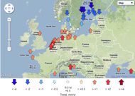
Click on map to browse sea level trends
Click on map to browse sea level anomalies
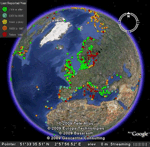
PSMSL tide gauges viewed with Google Earth
Google Earth can be used to give detailed views of the areas around PSMSL Revised Local Reference (RLR) tide gauges. Detailed information about the sites such as RLR monthly data and plots can be accessed. You will need to download and install the Google Earth viewer software first. You will then have to download and install the PSMSL tide gauge kml file and open it in Google Earth. Detailed instructions are listed below and it will only take a few minutes from start to finish.
System requirements:
Google Earth version 4.3 or higher. Google Earth only works well with DSL or faster bandwidth connections.
Instructions
1. Download and install Google Earth in your computer. [Important note: the PSMSL RLR tide gauges are not included in the Google Earth download, and it is not available at the Google Earth site. So even if you have installed Google Earth already, you must still do the next step (2) and download the PSMSL RLR tide gauges file from this site.]
2. Download the PSMSL RLR tide gauges file.
3. Start Google Earth.
4. Open the kml file in Google Earth. Google Earth will probably list the 'PSMSL RLR Catalogue' in the "My Places" column on the left-hand side. Alternatively, it may be in the "Temporary Places" folder towards the bottom. Check the box next to 'PSMSL RLR Catalogue' and Google Earth will display the network.
5. Select a PSMSL RLR tide gauge site. Click on a site from around the World and the details of that site will pop-up in a box. There are links for data and plots available from the selected gauge.
WARNING ABOUT POSITIONS OF GAUGES IN GOOGLE EARTH.
Positions of tide gauges in the PSMSL database are stored to the nearest minute in latitude and longitude. Consequently, gauge are not precisely located on the Google Earth maps and may appear to be in the sea or land. Local maps for many stations can be found in the GLOSS Station Handbook.

![]()
![]()
![]()
