Data
- Obtaining
- Supplying
- High-Frequency
- Bottom Pressure Records
- Other Long Records
- GLOSS/ODINAFRICA Calibration Data
Donate
Donate to PSMSL
Data Notes
- Individual Station Data and Plot Notes
- Referencing the Data Set
- PSMSL Help File
- 2010 Changes to the PSMSL Data Files
Extracted from Database
20 Jul 2026
Station Information
| Station ID: | 10 |
| Latitude: | 37.806667 |
| Longitude: | -122.465 |
| GLOSS ID: | 158 |
| Coastline code: | 823 |
| Station code: | 31 |
| Country: | UNITED STATES |
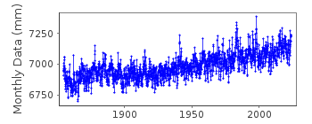
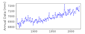
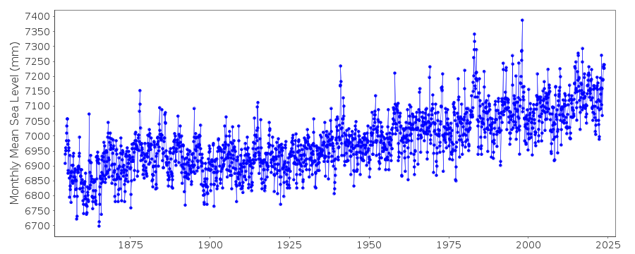
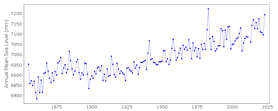
| Time span of data: | 1854 – 2025 |
| Completeness (%): | 99 |
| Date of last update: | 27 Jan 2026 |
| Green Arrow: | Current Station |
| Yellow Marker: | Neighbouring RLR Station |
| Red Marker: | Neighbouring Metric Station |
Please note: In many cases, the station position in our database is accurate to only one minute. Thus, the tide gauge may not appear to be on the coast.
Tide Gauge Data
Additional Data Sources (guide to additional data sources)
Nearby GNSS Stations from SONEL: SBRB, UCSF, PBL1, TIBB, SBRNNearby Real Time Stations from VLIZ: fpnt, fpnt2
Fast Delivery Data from UHSLC station 551: hourly and daily
Research Quality Data from UHSLC station 551: hourly and daily
Station Documentation
Link to RLR information.Documentation added 1991-06-11
San Francisco 823/031 RLR(1964) is 10.1m below BM180Documentation added 2011-07-26
The PSMSL record for San Francisco is made of three sections of data from 1854-1877 at Fort Point, 1878-1897 at Sausilito and for 1898 onwards at the Presidio Park. Datum differences at each site are reflected in the RLR factors which convert 'Metric' data to RLR. For a detailed discussion of the San Francisco record, see Smith, R.A. 1980. Golden Gate tidal measurements1854-1978. Journal of the waterways, Port Coastal and Ocean Division, Proceedings of the American Society of Civil Engineers, 106, 407-410. See also NOAA Technical Report NOS CO-OPS 035, Historical Golden Gate tidal series, 2002.
Documentation added 2012-09-18
For information: Data values during the early 1980's appear to be particularly high. This phenomenon could be due to the El Nino Southern Oscillation (ENSO)as it is mirrored all along the Californian coast.Data Authority
N.O.A.A. / N.O.S.N/oes33, Ssmc4, Room 6531
1305 East-West Highway
Silver Spring,
MD 20910

![]()
![]()
![]()
