Data
- Obtaining
- Supplying
- High-Frequency
- Bottom Pressure Records
- Other Long Records
- GLOSS/ODINAFRICA Calibration Data
Donate
Donate to PSMSL
Data Notes
- Individual Station Data and Plot Notes
- Referencing the Data Set
- PSMSL Help File
- 2010 Changes to the PSMSL Data Files
Extracted from Database
13 Jul 2026
WARNING: QCFLAG EXISTS. PLEASE READ THE DOCUMENTATION.
Station Information
| Station ID: | 1011 |
| Latitude: | 13.566667 |
| Longitude: | -89.833333 |
| GLOSS ID: | 182 |
| Coastline code: | 833 |
| Station code: | 11 |
| Country: | EL SALVADOR |
| Time span of data: | 1962 – 2001 |
| Completeness (%): | 96 |
| Date of last update: | 03 Sep 2015 |
| Green Arrow: | Current Station |
| Yellow Marker: | Neighbouring RLR Station |
| Red Marker: | Neighbouring Metric Station |
Please note: In many cases, the station position in our database is accurate to only one minute. Thus, the tide gauge may not appear to be on the coast.
Tide Gauge Data
Additional Data Sources (guide to additional data sources)
Nearby Real Time Stations from VLIZ: acajFast Delivery Data from UHSLC station 82: hourly and daily
Research Quality Data from UHSLC station 82: hourly and daily
Station Documentation
Link to RLR information.Documentation added 1993-07-12
Acajutla 833/011 RLR(1991) is 12.8m below BM CEPA-2Documentation added 1994-07-12
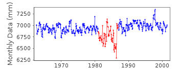
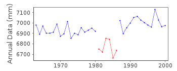
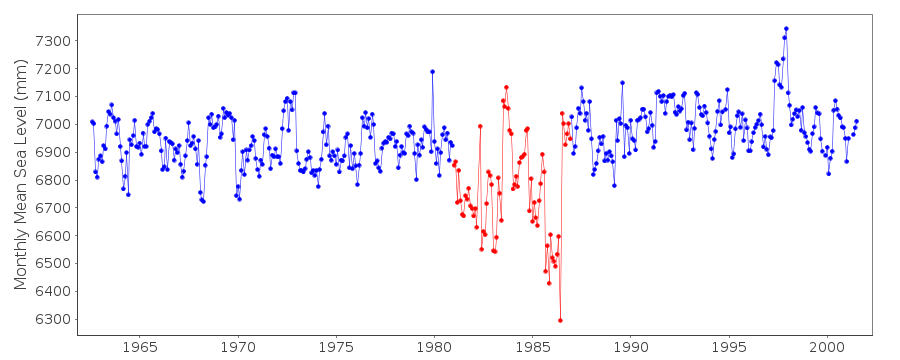
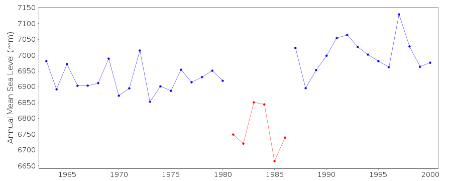
Many large spikes in the 1980s.Documentation added 2015-09-03
Additional data for 1992-2001 have been added to this data series using data downloaded from the Reasearch Quality daily values available from the UHSLC website. The UHSLC data contains values that have been adjusted based on confirmation of shifts in the analog data. These adjustments are uncertain to a few cm. This has not been done to the data held by PSMSL so when the total datasets are compared i.e UH data with PSMSL, data points may vary.Data Authority
Instituto Geografico NacionalApartado 247
Avenida Juan Bertis 79, Delgado
San Salvador

![]()
![]()
![]()
