Data
- Obtaining
- Supplying
- High-Frequency
- Bottom Pressure Records
- Other Long Records
- GLOSS/ODINAFRICA Calibration Data
Donate
Donate to PSMSL
Data Notes
- Individual Station Data and Plot Notes
- Referencing the Data Set
- PSMSL Help File
- 2010 Changes to the PSMSL Data Files
Extracted from Database
13 Jul 2026
Station Information
| Station ID: | 1033 |
| Latitude: | -38.372139 |
| Longitude: | 145.224694 |
| Coastline code: | 680 |
| Station code: | 178 |
| Country: | AUSTRALIA |
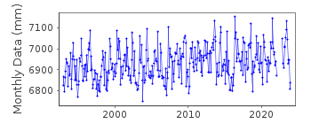
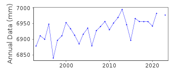
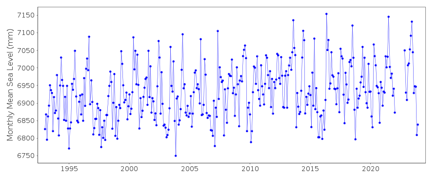
| Time span of RLR data: | 1993 – 2025 |
| RLR completeness (%): | 95 |
| Time span of metric data: | 1963 – 2025 |
| Metric completeness (%): | 71 |
| Link to ellipsoid: | Available |
| Date of last update: | 20 Mar 2025 |
| Green Arrow: | Current Station |
| Yellow Marker: | Neighbouring RLR Station |
| Red Marker: | Neighbouring Metric Station |
Please note: In many cases, the station position in our database is accurate to only one minute. Thus, the tide gauge may not appear to be on the coast.
Tide Gauge Data
Station Documentation
Link to RLR information.Documentation added 1995-05-02
Station density along some sections of the Australian coast has meant that station codes 601 onwards have been re-ordered compared to those in earlier versions of the PSMSL data set.Documentation added 1996-03-28
Revised data received from the National Tidal Centre, Bureau of Meteorology, South Australia. SEAFRAME station - owned and operated by the Port of Melbourne AuthorityDocumentation added 1996-04-02
SEAFRAME station installed January 1993Documentation added 2000-04-10
This is a "baseline station" of the Australian National Tidal Facility.Documentation added 2000-04-10
Stony Point 680/178 RLR(2000) is 10.524m below Bittern PM259Documentation added 2011-10-24
Using information from the National Tidal Centre the RLR diagram has been revised. Benchmark is Bittern PM259 5.124m above TGZ. The national datum AHD is 1.6m above TGZ. RLR factor is 5.4m.Documentation added 2017-01-31
The National Tidal Centre has re-processed the complete Stony Point data set. As well as this they have added 90mm to the data to refer the datum to LAT. LAT is defined as 5.214m below Primary Benchmark PM 259 Bittern. The complete dataset has been re-loaded and the RLR diagram re-drawn.Documentation added 2019-01-23
There is currently no updated values available for Stony Point. From the NTC website:- "The sea level sensor at Stony Point was raised in June 2017 to improve its capability of monitoring extreme sea levels, but the data won't be published until a new levelling survey has been preformed".Documentation added 2021-02-04
With reference to the above documentation recent data loaded was for the period July 2017 through to the December 2020.Data Authority
National Tidal CentreBureau of Meteorology
PO Box 421
Kent Town 5071
South Australia
Documentation added 2010-08-12
Formerly known as the National Tidal Facility

![]()
![]()
![]()
