Data
- Obtaining
- Supplying
- High-Frequency
- Bottom Pressure Records
- Other Long Records
- GLOSS/ODINAFRICA Calibration Data
Donate
Donate to PSMSL
Data Notes
- Individual Station Data and Plot Notes
- Referencing the Data Set
- PSMSL Help File
- 2010 Changes to the PSMSL Data Files
Extracted from Database
13 Jul 2026
Station Information
| Station ID: | 1038 |
| Latitude: | 26.553333 |
| Longitude: | -97.421667 |
| Coastline code: | 940 |
| Station code: | 2 |
| Country: | UNITED STATES |
| Time span of RLR data: | 1963 – 1997 |
| RLR completeness (%): | 90 |
| Time span of metric data: | 1963 – 2025 |
| Metric completeness (%): | 69 |
| Date of last update: | 09 Mar 2026 |
| Green Arrow: | Current Station |
| Yellow Marker: | Neighbouring RLR Station |
| Red Marker: | Neighbouring Metric Station |
Please note: In many cases, the station position in our database is accurate to only one minute. Thus, the tide gauge may not appear to be on the coast.
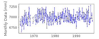
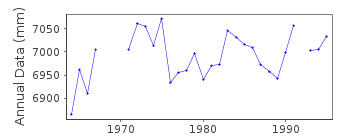
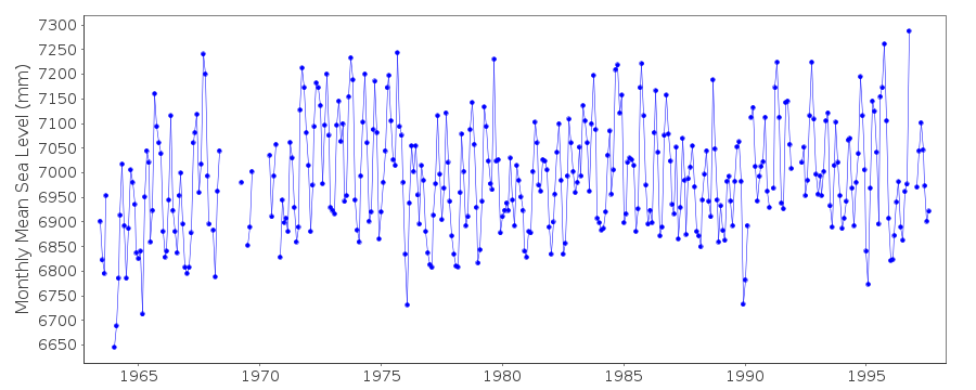
Tide Gauge Data
Station Documentation
Link to RLR information.Documentation added 1991-06-11
Port Mansfield 940/002 RLR(1967) is 10.7m below BM 6Documentation added 1993-07-29
Many stations on the Gulf coast have large values for September 1961.Documentation added 2011-11-24
Using information from the NOAA website the RLR diagram was revised. Primary benchmark is now NO 1 1964 4.121m above gauge datum.Documentation added 2014-02-12
This station has been re-instated dataset for Oct. 2012-Sept.2013 downloaded from NOAA. However, currently there is no supporting benchmark information to confirm the datum remains as before. Data has been loaded but marked 'Metric' until more information is available.Data Authority
N.O.A.A. / N.O.S.N/oes33, Ssmc4, Room 6531
1305 East-West Highway
Silver Spring,
MD 20910

![]()
![]()
![]()
